

Bolivia
THE HIDDEN SIDE OF ISLA DEL SOL
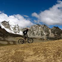
A cycling route starting in Yumani, La Paz Department, Bolivia.
Overview
About this route
The solution to discover and enjoy the other side of the Isla del Sol is bicycles.
- 30 min
- Duration
- 8.1 km
- Distance
- 95 m
- Ascent
- 215 m
- Descent
- 15.9 km/h
- Avg. speed
- 4,040 m
- Max. altitude

Part of
Bolivia
1 stage
Route photos


Route quality
Waytypes & surfaces along the route
Waytypes
Path
8.1 km
(100 %)
Surfaces
Unpaved
8.1 km
(100 %)
Gravel
6.5 km
(81 %)
Ground
1.5 km
(19 %)
Continue with Bikemap
Use, edit, or download this cycling route
You would like to ride THE HIDDEN SIDE OF ISLA DEL SOL or customize it for your own trip? Here is what you can do with this Bikemap route:
Free features
- Save this route as favorite or in collections
- Copy & plan your own version of this route
- Sync your route with Garmin or Wahoo
Premium features
Free trial for 3 days, or one-time payment. More about Bikemap Premium.
- Navigate this route on iOS & Android
- Export a GPX / KML file of this route
- Create your custom printout (try it for free)
- Download this route for offline navigation
Discover more Premium features.
Get Bikemap PremiumFrom our community
Other popular routes starting in Yumani
 THE HIDDEN SIDE OF ISLA DEL SOL
- Distance
- 8.1 km
- Ascent
- 95 m
- Descent
- 215 m
- Location
- Yumani, La Paz Department, Bolivia
 Copacabana - La Paz
- Distance
- 146.7 km
- Ascent
- 967 m
- Descent
- 1,038 m
- Location
- Yumani, La Paz Department, Bolivia
 Copacabana - San Pedro de tiquina
- Distance
- 39.4 km
- Ascent
- 601 m
- Descent
- 623 m
- Location
- Yumani, La Paz Department, Bolivia
 Bolivie
- Distance
- 1,435.7 km
- Ascent
- 3,871 m
- Descent
- 4,297 m
- Location
- Yumani, La Paz Department, Bolivia
 AN043 Copacabana - Huatajata
- Distance
- 67.4 km
- Ascent
- 1,037 m
- Descent
- 1,026 m
- Location
- Yumani, La Paz Department, Bolivia
 La Paz to Laguna Blanca to Salta
- Distance
- 1,885.8 km
- Ascent
- 23,484 m
- Descent
- 26,169 m
- Location
- Yumani, La Paz Department, Bolivia
 SASASD
- Distance
- 39.3 km
- Ascent
- 839 m
- Descent
- 859 m
- Location
- Yumani, La Paz Department, Bolivia
 Carrera del Titicaca
- Distance
- 103.5 km
- Ascent
- 1,329 m
- Descent
- 1,308 m
- Location
- Yumani, La Paz Department, Bolivia
Open it in the app