

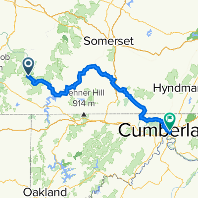
Four ridge route out of Ohiopyle
A cycling route starting in Dunbar, Pennsylvania, United States.
Overview
About this route
Water and food are available at stores in Confluence.
The descent on Turkeyfoot requires caution as the road is in poor condition.
The map shows a turnaround on Jim Mountain Road at the lowest point. With an extra climb up a steep ramp, the route could be extended into Normalville for water and food.
- -:--
- Duration
- 103.8 km
- Distance
- 1,863 m
- Ascent
- 1,857 m
- Descent
- ---
- Avg. speed
- ---
- Max. altitude
Route quality
Waytypes & surfaces along the route
Waytypes
Road
45.7 km
(44 %)
Quiet road
24.9 km
(24 %)
Surfaces
Paved
45.7 km
(44 %)
Asphalt
43.6 km
(42 %)
Paved (undefined)
2.1 km
(2 %)
Undefined
58.1 km
(56 %)
Continue with Bikemap
Use, edit, or download this cycling route
You would like to ride Four ridge route out of Ohiopyle or customize it for your own trip? Here is what you can do with this Bikemap route:
Free features
- Save this route as favorite or in collections
- Copy & plan your own version of this route
- Split it into stages to create a multi-day tour
- Sync your route with Garmin or Wahoo
Premium features
Free trial for 3 days, or one-time payment. More about Bikemap Premium.
- Navigate this route on iOS & Android
- Export a GPX / KML file of this route
- Create your custom printout (try it for free)
- Download this route for offline navigation
Discover more Premium features.
Get Bikemap PremiumFrom our community
Other popular routes starting in Dunbar
 Ohiopyle to West Newton
- Distance
- 68.1 km
- Ascent
- 154 m
- Descent
- 297 m
- Location
- Dunbar, Pennsylvania, United States
 Holland Hill Road, Dunbar to Holland Hill Road, Dunbar
- Distance
- 0 km
- Ascent
- 5 m
- Descent
- 0 m
- Location
- Dunbar, Pennsylvania, United States
 Ohiopyle to confluence
- Distance
- 17.5 km
- Ascent
- 44 m
- Descent
- 19 m
- Location
- Dunbar, Pennsylvania, United States
 Ohiopyle
- Distance
- 25.3 km
- Ascent
- 1,126 m
- Descent
- 1,126 m
- Location
- Dunbar, Pennsylvania, United States
 Four ridge route out of Ohiopyle
- Distance
- 103.8 km
- Ascent
- 1,863 m
- Descent
- 1,857 m
- Location
- Dunbar, Pennsylvania, United States
 Day 2
Day 2- Distance
- 104.3 km
- Ascent
- 2,183 m
- Descent
- 2,359 m
- Location
- Dunbar, Pennsylvania, United States
 Steady ride in 2waAqAQ22wqwaaq
- Distance
- 1.7 km
- Ascent
- 20 m
- Descent
- 53 m
- Location
- Dunbar, Pennsylvania, United States
 Aug 22, 2015, 1:45 PM
- Distance
- 30.3 km
- Ascent
- 391 m
- Descent
- 376 m
- Location
- Dunbar, Pennsylvania, United States
Open it in the app