

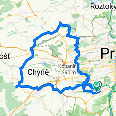
Z Pankráce na Karlštejn podél vody a přes kopečky zpět
A cycling route starting in Braník, Prague, Czechia.
Overview
About this route
In the first part, a completely comfortable route along the Vltava and Berounka, partly on unpaved surfaces up to Hlásná Třebáň. There we will sing a song by Ivan Mládek and right away the real climb begins (on the yellow trail, a blast but I recommend it) up to Karlštejn. Upon reaching the yellow trail, a bit of hell begins because from that moment on we will be moving through the hills. We continue on a long straight to Mořina, then across the field to Dolní Roblín. We face a relatively challenging ascent on a forest path (blue trail) to Roblín and there we have already won because a fantastic descent into Černošice awaits us. Then to Zbraslav, slalom among inliners to Braník and a climb up to Pankrác. You can start and finish at Na půli cesty.
- -:--
- Duration
- 65.6 km
- Distance
- 412 m
- Ascent
- 412 m
- Descent
- ---
- Avg. speed
- ---
- Max. altitude

Route highlights
Points of interest along the route
Point of interest after 3.1 km
Pro mě úžasnou novinkou bylo zjištění,že se Barandovský most dá přejet nakole.Doporučuji jet skutečně po levém břehu Vltavy, protože je jednak hezčí a jednak je tam méně lidí, než na inline stezce na pravém břehu.
Point of interest after 30.5 km
Tady se odpojíme od všech značek a dojedeme na nádraží. Za ním je most pro pěší, po něm přejdeme Berounku.
Point of interest after 31.1 km
Odsud dále pokračujeme po žluté turistické značce. Jasně, můžete jet po silnici, jestli jste másla.
Point of interest after 32.7 km
Pořád jedeme po žluté. Zde začíná jedno ze dvou poměrně těžkých stoupání po nezpevněné cestě.
Point of interest after 33.8 km
Kdo chce, podívá se na hrad. Má to za 500.
Point of interest after 36.8 km
Odsud pokračujeme po modré turistické značce, po polňačce a pak lesem.
Point of interest after 38.8 km
Čeká nás asi nejhorší stoupání, lesem, po nezpevněné cestě. Stále po modré turistické. Místy bude potřeba vzít kolo na záda, nebo ho tlačit.
Continue with Bikemap
Use, edit, or download this cycling route
You would like to ride Z Pankráce na Karlštejn podél vody a přes kopečky zpět or customize it for your own trip? Here is what you can do with this Bikemap route:
Free features
- Save this route as favorite or in collections
- Copy & plan your own version of this route
- Sync your route with Garmin or Wahoo
Premium features
Free trial for 3 days, or one-time payment. More about Bikemap Premium.
- Navigate this route on iOS & Android
- Export a GPX / KML file of this route
- Create your custom printout (try it for free)
- Download this route for offline navigation
Discover more Premium features.
Get Bikemap PremiumFrom our community
Other popular routes starting in Braník
 Barrandak - Říp - a zpět
- Distance
- 121.7 km
- Ascent
- 976 m
- Descent
- 978 m
- Location
- Braník, Prague, Czechia
 Sídliště Barrandov to Sídliště Barrandov
- Distance
- 59.7 km
- Ascent
- 662 m
- Descent
- 662 m
- Location
- Braník, Prague, Czechia
 Velká ohrada - Černošice - podél Berounky a Vltavy - Prokopák
- Distance
- 38.5 km
- Ascent
- 398 m
- Descent
- 398 m
- Location
- Braník, Prague, Czechia
 lehká trasa po Praze
- Distance
- 39.1 km
- Ascent
- 316 m
- Descent
- 316 m
- Location
- Braník, Prague, Czechia
 Kat 1 - Route 1
- Distance
- 41.7 km
- Ascent
- 362 m
- Descent
- 362 m
- Location
- Braník, Prague, Czechia
 Klasika Cernosice :)
- Distance
- 35.5 km
- Ascent
- 428 m
- Descent
- 437 m
- Location
- Braník, Prague, Czechia
 Barrandak - Orech - Lodenice - Unhost - Prokopak - Barrandak
- Distance
- 78.6 km
- Ascent
- 1,073 m
- Descent
- 945 m
- Location
- Braník, Prague, Czechia
 Jizni Praha
- Distance
- 38.4 km
- Ascent
- 321 m
- Descent
- 309 m
- Location
- Braník, Prague, Czechia
Open it in the app