Burlington to Bellingham
A cycling route starting in Burlington, Washington, United States.
Overview
About this route
The first half to two-thirds of the ride was pretty much flat through nice agricultural areas.
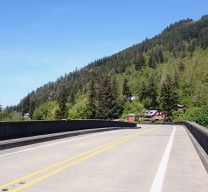
After the flat portion of the ride, we got onto Chuckanut Drive, which is really a beautiful road along the coast south of Bellingham that rises and falls a number of times. The only downsides are a little too much traffic, though not uncomfortably so for us, and the lack of road shoulder. There are a few lookout points, though with the trees below the lookout points growing up, the view of Puget Sound was nice, but not as panoramic as it would otherwise be.
Overall, great ride with good road conditions and nice countryside and views.
- 4 h 27 min
- Duration
- 52.8 km
- Distance
- 635 m
- Ascent
- 590 m
- Descent
- 11.9 km/h
- Avg. speed
- 98 m
- Max. altitude
Route photos
Route quality
Waytypes & surfaces along the route
Waytypes
Busy road
31.7 km
(60 %)
Road
10.9 km
(21 %)
Surfaces
Paved
32.7 km
(62 %)
Unpaved
0.2 km
(<1 %)
Asphalt
29.4 km
(56 %)
Concrete
3.3 km
(6 %)
Continue with Bikemap
Use, edit, or download this cycling route
You would like to ride Burlington to Bellingham or customize it for your own trip? Here is what you can do with this Bikemap route:
Free features
- Save this route as favorite or in collections
- Copy & plan your own version of this route
- Sync your route with Garmin or Wahoo
Premium features
Free trial for 3 days, or one-time payment. More about Bikemap Premium.
- Navigate this route on iOS & Android
- Export a GPX / KML file of this route
- Create your custom printout (try it for free)
- Download this route for offline navigation
Discover more Premium features.
Get Bikemap PremiumFrom our community
Other popular routes starting in Burlington
 Mt. Constitution
- Distance
- 265 km
- Ascent
- 682 m
- Descent
- 550 m
- Location
- Burlington, Washington, United States
 Recording from September 18, 9:53 PM
- Distance
- 7.8 km
- Ascent
- 8 m
- Descent
- 8 m
- Location
- Burlington, Washington, United States
 Recording from October 25, 12:35 AM
- Distance
- 7.3 km
- Ascent
- 10 m
- Descent
- 8 m
- Location
- Burlington, Washington, United States
 5530 Chuckanut Dr, Bow to 14969 W Bow Hill Rd, Bow
- Distance
- 47.1 km
- Ascent
- 761 m
- Descent
- 758 m
- Location
- Burlington, Washington, United States
 EdisonSchool-SamishIsland
- Distance
- 20.5 km
- Ascent
- 62 m
- Descent
- 63 m
- Location
- Burlington, Washington, United States
 Recording from September 18, 4:29 PM
- Distance
- 12.1 km
- Ascent
- 0 m
- Descent
- 0 m
- Location
- Burlington, Washington, United States
 Burlington to Bellingham
- Distance
- 52.8 km
- Ascent
- 635 m
- Descent
- 590 m
- Location
- Burlington, Washington, United States
 Recording from October 24, 11:54 PM
- Distance
- 7.6 km
- Ascent
- 9 m
- Descent
- 11 m
- Location
- Burlington, Washington, United States
Open it in the app


