

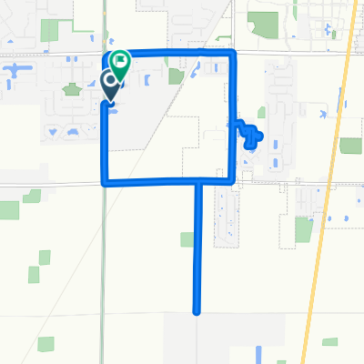
1011 Brampton Park Rd, Perrysburg to 1025 Brampton Park Rd, Perrysburg
A cycling route starting in Waterville, Ohio, United States.
Overview
About this route
- 1 h 18 min
- Duration
- 21.5 km
- Distance
- 47 m
- Ascent
- 48 m
- Descent
- 16.7 km/h
- Avg. speed
- 202 m
- Max. altitude

Continue with Bikemap
Use, edit, or download this cycling route
You would like to ride 1011 Brampton Park Rd, Perrysburg to 1025 Brampton Park Rd, Perrysburg or customize it for your own trip? Here is what you can do with this Bikemap route:
Free features
- Save this route as favorite or in collections
- Copy & plan your own version of this route
- Sync your route with Garmin or Wahoo
Premium features
Free trial for 3 days, or one-time payment. More about Bikemap Premium.
- Navigate this route on iOS & Android
- Export a GPX / KML file of this route
- Create your custom printout (try it for free)
- Download this route for offline navigation
Discover more Premium features.
Get Bikemap PremiumFrom our community
Other popular routes starting in Waterville
 8025 Monclova Rd, Monclova to 8025 Monclova Rd, Monclova
- Distance
- 28.6 km
- Ascent
- 35 m
- Descent
- 39 m
- Location
- Waterville, Ohio, United States
 1070 Waterville-Monclova Rd, Waterville to 1070 Waterville-Monclova Rd, Waterville
- Distance
- 8.4 km
- Ascent
- 4 m
- Descent
- 0 m
- Location
- Waterville, Ohio, United States
 741 S River Rd, Waterville to 741 S River Rd, Waterville
- Distance
- 29.3 km
- Ascent
- 108 m
- Descent
- 108 m
- Location
- Waterville, Ohio, United States
 Brampton Park Rd, Perrysburg to Brampton Park Rd, Perrysburg
- Distance
- 11.4 km
- Ascent
- 13 m
- Descent
- 10 m
- Location
- Waterville, Ohio, United States
 741 S River Rd, Waterville to 12630 Grand Rapids Rd, Grand Rapids
- Distance
- 14.6 km
- Ascent
- 40 m
- Descent
- 25 m
- Location
- Waterville, Ohio, United States
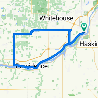 Anthony Wayne Trail, Waterville to Anthony Wayne Trail, Waterville
- Distance
- 49.8 km
- Ascent
- 60 m
- Descent
- 57 m
- Location
- Waterville, Ohio, United States
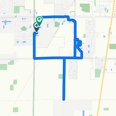 Brampton Park Rd, Perrysburg to Brampton Park Rd, Perrysburg
- Distance
- 12.1 km
- Ascent
- 31 m
- Descent
- 34 m
- Location
- Waterville, Ohio, United States
 1011 Brampton Park Rd, Perrysburg to 1025 Brampton Park Rd, Perrysburg
- Distance
- 21.5 km
- Ascent
- 47 m
- Descent
- 48 m
- Location
- Waterville, Ohio, United States
Open it in the app