

Recorded via Apple Watch at 14 May at 21:56
A cycling route starting in Zürich (Kreis 4) / Aussersihl, Canton of Zurich, Switzerland.
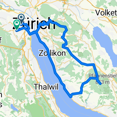
Overview
About this route
- 15 min
- Duration
- 6.2 km
- Distance
- 44 m
- Ascent
- 21 m
- Descent
- 24.6 km/h
- Avg. speed
- 418 m
- Max. altitude
Route quality
Waytypes & surfaces along the route
Waytypes
Road
2.5 km
(40 %)
Quiet road
1.2 km
(19 %)
Surfaces
Paved
6.1 km
(99 %)
Asphalt
6 km
(97 %)
Paved (undefined)
0.1 km
(2 %)
Undefined
0.1 km
(1 %)
Continue with Bikemap
Use, edit, or download this cycling route
You would like to ride Recorded via Apple Watch at 14 May at 21:56 or customize it for your own trip? Here is what you can do with this Bikemap route:
Free features
- Save this route as favorite or in collections
- Copy & plan your own version of this route
- Sync your route with Garmin or Wahoo
Premium features
Free trial for 3 days, or one-time payment. More about Bikemap Premium.
- Navigate this route on iOS & Android
- Export a GPX / KML file of this route
- Create your custom printout (try it for free)
- Download this route for offline navigation
Discover more Premium features.
Get Bikemap PremiumFrom our community
Other popular routes starting in Zürich (Kreis 4) / Aussersihl
 Bäcki-Türlersee-Ägerisee-Gottschalkenberg-Hirzel-Bäcki
- Distance
- 85 km
- Ascent
- 1,052 m
- Descent
- 1,049 m
- Location
- Zürich (Kreis 4) / Aussersihl, Canton of Zurich, Switzerland
 bike tour from Zürich to Bonstetten
- Distance
- 16.7 km
- Ascent
- 311 m
- Descent
- 183 m
- Location
- Zürich (Kreis 4) / Aussersihl, Canton of Zurich, Switzerland
 Züri-Sattelegg-Züri
- Distance
- 104.7 km
- Ascent
- 924 m
- Descent
- 921 m
- Location
- Zürich (Kreis 4) / Aussersihl, Canton of Zurich, Switzerland
 Uetliberg
- Distance
- 15.1 km
- Ascent
- 485 m
- Descent
- 483 m
- Location
- Zürich (Kreis 4) / Aussersihl, Canton of Zurich, Switzerland
 Zürich-Pfannenstil-Zürich
- Distance
- 46.6 km
- Ascent
- 577 m
- Descent
- 562 m
- Location
- Zürich (Kreis 4) / Aussersihl, Canton of Zurich, Switzerland
 Zurich - Rapperswil
- Distance
- 31.4 km
- Ascent
- 134 m
- Descent
- 101 m
- Location
- Zürich (Kreis 4) / Aussersihl, Canton of Zurich, Switzerland
 Türlersee Rundfahrt
- Distance
- 51.9 km
- Ascent
- 637 m
- Descent
- 644 m
- Location
- Zürich (Kreis 4) / Aussersihl, Canton of Zurich, Switzerland
 Hügelrunde-Süd Februar
- Distance
- 69 km
- Ascent
- 778 m
- Descent
- 777 m
- Location
- Zürich (Kreis 4) / Aussersihl, Canton of Zurich, Switzerland
Open it in the app