

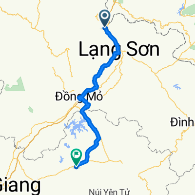
Ping Xiang to Nang Nin
A cycling route starting in Thị Trấn Cao Lộc, Lạng Sơn Province, Vietnam.
Overview
About this route
- -:--
- Duration
- 241.9 km
- Distance
- 650 m
- Ascent
- 883 m
- Descent
- ---
- Avg. speed
- ---
- Max. altitude

Continue with Bikemap
Use, edit, or download this cycling route
You would like to ride Ping Xiang to Nang Nin or customize it for your own trip? Here is what you can do with this Bikemap route:
Free features
- Save this route as favorite or in collections
- Copy & plan your own version of this route
- Split it into stages to create a multi-day tour
- Sync your route with Garmin or Wahoo
Premium features
Free trial for 3 days, or one-time payment. More about Bikemap Premium.
- Navigate this route on iOS & Android
- Export a GPX / KML file of this route
- Create your custom printout (try it for free)
- Download this route for offline navigation
Discover more Premium features.
Get Bikemap PremiumFrom our community
Other popular routes starting in Thị Trấn Cao Lộc
 Guangxi
- Distance
- 1,078.4 km
- Ascent
- 1,290 m
- Descent
- 1,455 m
- Location
- Thị Trấn Cao Lộc, Lạng Sơn Province, Vietnam
 VietNam
- Distance
- 663.9 km
- Ascent
- 902 m
- Descent
- 810 m
- Location
- Thị Trấn Cao Lộc, Lạng Sơn Province, Vietnam
 クラッキング・ライド
- Distance
- 15.4 km
- Ascent
- 68 m
- Descent
- 38 m
- Location
- Thị Trấn Cao Lộc, Lạng Sơn Province, Vietnam
 National Route 1A (Vietnam)
- Distance
- 2,332.9 km
- Ascent
- 418 m
- Descent
- 728 m
- Location
- Thị Trấn Cao Lộc, Lạng Sơn Province, Vietnam
 Dong Dang - Luc Ngan
- Distance
- 102.4 km
- Ascent
- 503 m
- Descent
- 761 m
- Location
- Thị Trấn Cao Lộc, Lạng Sơn Province, Vietnam
 Vietnam et Laos
- Distance
- 1,792.7 km
- Ascent
- 2,152 m
- Descent
- 2,093 m
- Location
- Thị Trấn Cao Lộc, Lạng Sơn Province, Vietnam
 Ping Xiang to Nang Nin
- Distance
- 241.9 km
- Ascent
- 650 m
- Descent
- 883 m
- Location
- Thị Trấn Cao Lộc, Lạng Sơn Province, Vietnam
 Pingxiang - Mingjiangzhen
- Distance
- 63.3 km
- Ascent
- 343 m
- Descent
- 530 m
- Location
- Thị Trấn Cao Lộc, Lạng Sơn Province, Vietnam
Open it in the app