

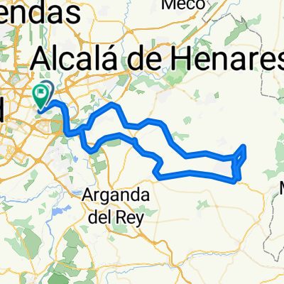
Coslada - Los Hueros - Torres de la Alameda - Coslada
A cycling route starting in Coslada, Madrid, Spain.
Overview
About this route
Ascent to Los Hueros on asphalt (not to be underestimated) and descent via a singletrack trail.
- -:--
- Duration
- 57.3 km
- Distance
- 462 m
- Ascent
- 457 m
- Descent
- ---
- Avg. speed
- ---
- Max. altitude

Route highlights
Points of interest along the route
Point of interest after 28.5 km
Bifurcación (aún en el asfalto). Giramos a la derecha.
Point of interest after 28.9 km
La siguiente decisión: izquierda, derecha o de frente. Nosotros seguimos por el camino de en medio.
Point of interest after 29.1 km
A la izquierda nace un camino. Lo tomamos.
Point of interest after 29.7 km
Continuamos pegados a la verja.
Point of interest after 30.5 km
Comienza el descenso, igual de técnico.
Point of interest after 31.4 km
A la salida del desfiladero, atravesamos un sembrado y, al llegar a una pista más ancha, descendemos por la izquierda.
Continue with Bikemap
Use, edit, or download this cycling route
You would like to ride Coslada - Los Hueros - Torres de la Alameda - Coslada or customize it for your own trip? Here is what you can do with this Bikemap route:
Free features
- Save this route as favorite or in collections
- Copy & plan your own version of this route
- Sync your route with Garmin or Wahoo
Premium features
Free trial for 3 days, or one-time payment. More about Bikemap Premium.
- Navigate this route on iOS & Android
- Export a GPX / KML file of this route
- Create your custom printout (try it for free)
- Download this route for offline navigation
Discover more Premium features.
Get Bikemap PremiumFrom our community
Other popular routes starting in Coslada
 Coslada - Velilla de San Antonio - Campo Real - Arganda del Rey -Velilla de San Antonio - Coslada
- Distance
- 55.4 km
- Ascent
- 311 m
- Descent
- 311 m
- Location
- Coslada, Madrid, Spain
 39 bis 20251019 Nuevo Baztán 90 km
- Distance
- 89.7 km
- Ascent
- 6,536 m
- Descent
- 6,546 m
- Location
- Coslada, Madrid, Spain
 Coslada - Villalbilla
- Distance
- 30.6 km
- Ascent
- 219 m
- Descent
- 114 m
- Location
- Coslada, Madrid, Spain
 Coslada - Paracuellos del Jarama - Dehesa de Cobeña - Daganzo de Arriba - Coslada
- Distance
- 57.2 km
- Ascent
- 340 m
- Descent
- 345 m
- Location
- Coslada, Madrid, Spain
 De Calle Varsovia 19, Coslada a Calle Varsovia 19, Coslada
- Distance
- 47.2 km
- Ascent
- 283 m
- Descent
- 335 m
- Location
- Coslada, Madrid, Spain
 Coslada - El Goloso - Coslada
- Distance
- 60.7 km
- Ascent
- 286 m
- Descent
- 292 m
- Location
- Coslada, Madrid, Spain
 Propuesta Red MTB 2010 Corredor del Henares
- Distance
- 49.7 km
- Ascent
- 296 m
- Descent
- 316 m
- Location
- Coslada, Madrid, Spain
 Coslada - Torres de la Alameda - Valverde de Alcalá - Villalbilla - Los Hueros - Coslada
- Distance
- 67.2 km
- Ascent
- 406 m
- Descent
- 408 m
- Location
- Coslada, Madrid, Spain
Open it in the app