

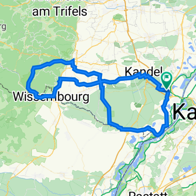
Deutsch-Französische Maifahrt 2010 - RTF des RSC Wörth 1980 e.V. - 133 km Strecke
A cycling route starting in Wörth am Rhein, Rhineland-Palatinate, Germany.
Overview
About this route
Deutsch-Französische Maifahrt 2010 - 133 km
RTF des RSC Wörth 1980 e.V.
Alle weiteren Hinweise zu dieser Strecke -> hier anklicken
- -:--
- Duration
- 123.8 km
- Distance
- 601 m
- Ascent
- 601 m
- Descent
- ---
- Avg. speed
- ---
- Max. altitude

Route quality
Waytypes & surfaces along the route
Waytypes
Busy road
39.2 km
(32 %)
Road
38.2 km
(31 %)
Surfaces
Paved
105 km
(85 %)
Unpaved
3.7 km
(3 %)
Asphalt
96.7 km
(78 %)
Paved (undefined)
3.7 km
(3 %)
Route highlights
Points of interest along the route
Point of interest after 82.7 km
Kontrolle <b>Col de Pfaffenschlick</b>
Point of interest after 102.8 km
Kontrolle <b>Niederotterbach</b><br>wurde 2 mal angesteuert
Continue with Bikemap
Use, edit, or download this cycling route
You would like to ride Deutsch-Französische Maifahrt 2010 - RTF des RSC Wörth 1980 e.V. - 133 km Strecke or customize it for your own trip? Here is what you can do with this Bikemap route:
Free features
- Save this route as favorite or in collections
- Copy & plan your own version of this route
- Split it into stages to create a multi-day tour
- Sync your route with Garmin or Wahoo
Premium features
Free trial for 3 days, or one-time payment. More about Bikemap Premium.
- Navigate this route on iOS & Android
- Export a GPX / KML file of this route
- Create your custom printout (try it for free)
- Download this route for offline navigation
Discover more Premium features.
Get Bikemap PremiumFrom our community
Other popular routes starting in Wörth am Rhein
 zum Schloßgarten und zum Brauhaus
- Distance
- 25.3 km
- Ascent
- 79 m
- Descent
- 80 m
- Location
- Wörth am Rhein, Rhineland-Palatinate, Germany
 Knielingen-Rhein-Mühlburg-Knielingen
- Distance
- 15.2 km
- Ascent
- 34 m
- Descent
- 29 m
- Location
- Wörth am Rhein, Rhineland-Palatinate, Germany
 Deutsch-Französische Maifahrt 2010 - RTF des RSC Wörth 1980 e.V. - 164 km Strecke
- Distance
- 150 km
- Ascent
- 650 m
- Descent
- 650 m
- Location
- Wörth am Rhein, Rhineland-Palatinate, Germany
 Maxau, Wissembourg, Kandel, Maxau
- Distance
- 72.9 km
- Ascent
- 154 m
- Descent
- 150 m
- Location
- Wörth am Rhein, Rhineland-Palatinate, Germany
 44_Wörth – Lauterbourg (F) – Wörth
- Distance
- 37.6 km
- Ascent
- 71 m
- Descent
- 71 m
- Location
- Wörth am Rhein, Rhineland-Palatinate, Germany
 Richard-Wagner-Straße nach Am Neuen Rheinhafen
- Distance
- 49.7 km
- Ascent
- 165 m
- Descent
- 186 m
- Location
- Wörth am Rhein, Rhineland-Palatinate, Germany
 Elsassrunde
- Distance
- 60.2 km
- Ascent
- 176 m
- Descent
- 187 m
- Location
- Wörth am Rhein, Rhineland-Palatinate, Germany
 Deutsch-Französische Maifahrt - RTF des RSC Wörth 1980 e.V. - 91 km Strecke
- Distance
- 88.8 km
- Ascent
- 305 m
- Descent
- 305 m
- Location
- Wörth am Rhein, Rhineland-Palatinate, Germany
Open it in the app