

frage an die user: geteert oder nicht.?
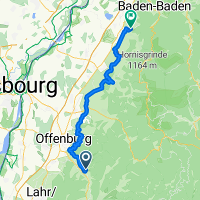
A cycling route starting in Gengenbach, Hesse, Germany.
Overview
About this route
looks lie a nice shortcut - is it paved or not?
- -:--
- Duration
- 8.4 km
- Distance
- 422 m
- Ascent
- 290 m
- Descent
- ---
- Avg. speed
- ---
- Max. altitude
Route quality
Waytypes & surfaces along the route
Waytypes
Quiet road
6.4 km
(76 %)
Track
2 km
(24 %)
Surfaces
Paved
2 km
(24 %)
Unpaved
1.6 km
(19 %)
Asphalt
2 km
(24 %)
Unpaved (undefined)
0.9 km
(11 %)
Continue with Bikemap
Use, edit, or download this cycling route
You would like to ride frage an die user: geteert oder nicht.? or customize it for your own trip? Here is what you can do with this Bikemap route:
Free features
- Save this route as favorite or in collections
- Copy & plan your own version of this route
- Sync your route with Garmin or Wahoo
Premium features
Free trial for 3 days, or one-time payment. More about Bikemap Premium.
- Navigate this route on iOS & Android
- Export a GPX / KML file of this route
- Create your custom printout (try it for free)
- Download this route for offline navigation
Discover more Premium features.
Get Bikemap PremiumFrom our community
Other popular routes starting in Gengenbach
 Strohbach
- Distance
- 18.6 km
- Ascent
- 620 m
- Descent
- 607 m
- Location
- Gengenbach, Hesse, Germany
 Von Gengenbach über Kornebene nach Steinenbach und zurück
- Distance
- 42.3 km
- Ascent
- 1,249 m
- Descent
- 1,257 m
- Location
- Gengenbach, Hesse, Germany
 Gengenbach - Lahr - Biberach - Gengenbach
- Distance
- 50.9 km
- Ascent
- 275 m
- Descent
- 275 m
- Location
- Gengenbach, Hesse, Germany
 Gengenbach, Zuflucht, Bad Rippoldsau
- Distance
- 110.5 km
- Ascent
- 927 m
- Descent
- 929 m
- Location
- Gengenbach, Hesse, Germany
 3. Etappe von Gengenbach nach Bühl
- Distance
- 58.7 km
- Ascent
- 683 m
- Descent
- 695 m
- Location
- Gengenbach, Hesse, Germany
 7-Täler-Weg Gengenbach nach Biberach CLONED FROM ROUTE 1607693
- Distance
- 18.5 km
- Ascent
- 517 m
- Descent
- 495 m
- Location
- Gengenbach, Hesse, Germany
 3 tägige Scharzwaldtour - Tag 2
- Distance
- 51.1 km
- Ascent
- 1,634 m
- Descent
- 1,211 m
- Location
- Gengenbach, Hesse, Germany
 Gengenbach-Offenburg-Schutterzell-Niederschopfheim-Zunsweier-Gengenbach
- Distance
- 54.2 km
- Ascent
- 89 m
- Descent
- 87 m
- Location
- Gengenbach, Hesse, Germany
Open it in the app