

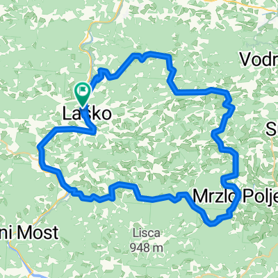
Laško -Zidani most-Laško
A cycling route starting in Laško, Laško Municipality, Slovenia.
Overview
About this route
- 1 h 47 min
- Duration
- 29 km
- Distance
- 238 m
- Ascent
- 289 m
- Descent
- 16.3 km/h
- Avg. speed
- 283 m
- Max. altitude

Route photos


Route quality
Waytypes & surfaces along the route
Waytypes
Quiet road
17.4 km
(60 %)
Road
4.4 km
(15 %)
Surfaces
Paved
22.1 km
(76 %)
Asphalt
22.1 km
(76 %)
Undefined
7 km
(24 %)
Continue with Bikemap
Use, edit, or download this cycling route
You would like to ride Laško -Zidani most-Laško or customize it for your own trip? Here is what you can do with this Bikemap route:
Free features
- Save this route as favorite or in collections
- Copy & plan your own version of this route
- Sync your route with Garmin or Wahoo
Premium features
Free trial for 3 days, or one-time payment. More about Bikemap Premium.
- Navigate this route on iOS & Android
- Export a GPX / KML file of this route
- Create your custom printout (try it for free)
- Download this route for offline navigation
Discover more Premium features.
Get Bikemap PremiumFrom our community
Other popular routes starting in Laško
 Jagoče - Svetina
- Distance
- 9.4 km
- Ascent
- 568 m
- Descent
- 105 m
- Location
- Laško, Laško Municipality, Slovenia
 Laški krog 4. etapa
- Distance
- 32.4 km
- Ascent
- 985 m
- Descent
- 988 m
- Location
- Laško, Laško Municipality, Slovenia
 Malič
Malič- Distance
- 9.6 km
- Ascent
- 706 m
- Descent
- 0 m
- Location
- Laško, Laško Municipality, Slovenia
 Šentrupert (8)
- Distance
- 26.7 km
- Ascent
- 519 m
- Descent
- 516 m
- Location
- Laško, Laško Municipality, Slovenia
 VI-Lj9: Rimske Toplice - Slovenska Bistrica, 70,1km 860hm
- Distance
- 70.1 km
- Ascent
- 1,125 m
- Descent
- 1,065 m
- Location
- Laško, Laško Municipality, Slovenia
 Šmohor (4)
- Distance
- 26.3 km
- Ascent
- 633 m
- Descent
- 633 m
- Location
- Laško, Laško Municipality, Slovenia
 Laško -Zidani most-Laško
- Distance
- 29 km
- Ascent
- 238 m
- Descent
- 289 m
- Location
- Laško, Laško Municipality, Slovenia
 Hribovje nad Laškim
- Distance
- 52.9 km
- Ascent
- 739 m
- Descent
- 741 m
- Location
- Laško, Laško Municipality, Slovenia
Open it in the app