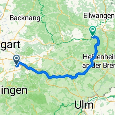
Unterensingen - Untersteinbach
A cycling route starting in Unterensingen, Baden-Württemberg, Germany.
Overview
About this route
- 5 h 58 min
- Duration
- 85.5 km
- Distance
- 1,578 m
- Ascent
- 1,599 m
- Descent
- 14.3 km/h
- Avg. speed
- 575 m
- Avg. speed
Route quality
Waytypes & surfaces along the route
Waytypes
Quiet road
30.8 km
(36 %)
Busy road
16.1 km
(19 %)
Surfaces
Paved
63.2 km
(74 %)
Unpaved
6.9 km
(8 %)
Asphalt
60.8 km
(71 %)
Gravel
5 km
(6 %)
Continue with Bikemap
Use, edit, or download this cycling route
You would like to ride Unterensingen - Untersteinbach or customize it for your own trip? Here is what you can do with this Bikemap route:
Free features
- Save this route as favorite or in collections
- Copy & plan your own version of this route
- Sync your route with Garmin or Wahoo
Premium features
Free trial for 3 days, or one-time payment. More about Bikemap Premium.
- Navigate this route on iOS & Android
- Export a GPX / KML file of this route
- Create your custom printout (try it for free)
- Download this route for offline navigation
Discover more Premium features.
Get Bikemap PremiumFrom our community
Other popular routes starting in Unterensingen
- Neuffen-Urach-St-Johann-Glems-N'tailfingen
- Distance
- 82.3 km
- Ascent
- 1,318 m
- Descent
- 1,297 m
- Location
- Unterensingen, Baden-Württemberg, Germany
- Ehestetten ROSE.
- Distance
- 63.5 km
- Ascent
- 657 m
- Descent
- 206 m
- Location
- Unterensingen, Baden-Württemberg, Germany
- Unterensingen - Untersteinbach
- Distance
- 85.5 km
- Ascent
- 1,578 m
- Descent
- 1,599 m
- Location
- Unterensingen, Baden-Württemberg, Germany
- Neckar Richtung Metzingen
- Distance
- 39.5 km
- Ascent
- 156 m
- Descent
- 156 m
- Location
- Unterensingen, Baden-Württemberg, Germany
- KLeine Feierabendrunde 50km
- Distance
- 48.8 km
- Ascent
- 663 m
- Descent
- 651 m
- Location
- Unterensingen, Baden-Württemberg, Germany
- U'ensingen - Lautlingen
- Distance
- 92.8 km
- Ascent
- 1,136 m
- Descent
- 720 m
- Location
- Unterensingen, Baden-Württemberg, Germany
- Hometour
- Distance
- 5.6 km
- Ascent
- 32 m
- Descent
- 50 m
- Location
- Unterensingen, Baden-Württemberg, Germany
- Schönbuch - Deckenpfronn - BB
- Distance
- 82.9 km
- Ascent
- 642 m
- Descent
- 557 m
- Location
- Unterensingen, Baden-Württemberg, Germany
Open it in the app