

2024_05_24_B Schallerbach-Scharten-Schallerbach
A cycling route starting in Bad Schallerbach, Upper Austria, Austria.
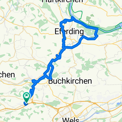
Overview
About this route
- 1 h 50 min
- Duration
- 27.2 km
- Distance
- 375 m
- Ascent
- 373 m
- Descent
- 14.9 km/h
- Avg. speed
- 447 m
- Max. altitude

Route quality
Waytypes & surfaces along the route
Waytypes
Quiet road
12.5 km
(46 %)
Road
7.3 km
(27 %)
Surfaces
Paved
6.3 km
(23 %)
Unpaved
1.6 km
(6 %)
Asphalt
6.3 km
(23 %)
Gravel
1.6 km
(6 %)
Undefined
19.3 km
(71 %)
Continue with Bikemap
Use, edit, or download this cycling route
You would like to ride 2024_05_24_B Schallerbach-Scharten-Schallerbach or customize it for your own trip? Here is what you can do with this Bikemap route:
Free features
- Save this route as favorite or in collections
- Copy & plan your own version of this route
- Sync your route with Garmin or Wahoo
Premium features
Free trial for 3 days, or one-time payment. More about Bikemap Premium.
- Navigate this route on iOS & Android
- Export a GPX / KML file of this route
- Create your custom printout (try it for free)
- Download this route for offline navigation
Discover more Premium features.
Get Bikemap PremiumFrom our community
Other popular routes starting in Bad Schallerbach
 Vorschlag 1. Mai
- Distance
- 17.4 km
- Ascent
- 221 m
- Descent
- 222 m
- Location
- Bad Schallerbach, Upper Austria, Austria
 OBK 250402 Spargelzeit
- Distance
- 62 km
- Ascent
- 219 m
- Descent
- 224 m
- Location
- Bad Schallerbach, Upper Austria, Austria
 OBK Pichl 23.5.29 Turmkeller
- Distance
- 55.9 km
- Ascent
- 1,031 m
- Descent
- 1,019 m
- Location
- Bad Schallerbach, Upper Austria, Austria
 140km Pichl - Wesenufer - St. Martin - Scharten - Pichl
- Distance
- 140.9 km
- Ascent
- 1,160 m
- Descent
- 1,160 m
- Location
- Bad Schallerbach, Upper Austria, Austria
 OBK 250402 Spargelzeit
- Distance
- 62 km
- Ascent
- 219 m
- Descent
- 224 m
- Location
- Bad Schallerbach, Upper Austria, Austria
 2014 - Pichl / Inzing (400km / 4400Hm)
- Distance
- 392.8 km
- Ascent
- 3,329 m
- Descent
- 3,096 m
- Location
- Bad Schallerbach, Upper Austria, Austria
 kur 2
kur 2- Distance
- 83 km
- Ascent
- 2,041 m
- Descent
- 2,039 m
- Location
- Bad Schallerbach, Upper Austria, Austria
 Krenglbach - St. Agatha - Haibach - Scharten
- Distance
- 83.2 km
- Ascent
- 892 m
- Descent
- 897 m
- Location
- Bad Schallerbach, Upper Austria, Austria
Open it in the app