
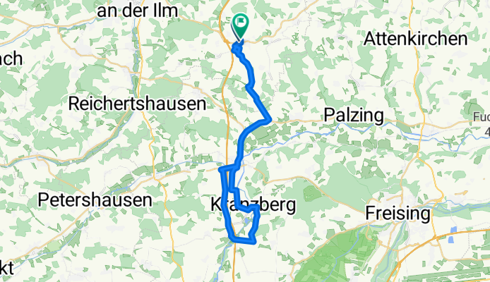
Am Sportplatz 1, Schweitenkirchen nach St-Kastulus-Straße 14, Schweitenkirchen
A cycling route starting in Schweitenkirchen, Bavaria, Germany.
Overview
About this route
- 1 h 58 min
- Duration
- 36.9 km
- Distance
- 175 m
- Ascent
- 163 m
- Descent
- 18.8 km/h
- Avg. speed
- 528 m
- Max. altitude

Route quality
Waytypes & surfaces along the route
Waytypes
Quiet road
13.2 km
(36 %)
Road
10.4 km
(28 %)
Surfaces
Paved
25.4 km
(69 %)
Unpaved
0.6 km
(2 %)
Asphalt
25.4 km
(69 %)
Gravel
0.6 km
(2 %)
Undefined
10.9 km
(30 %)
Continue with Bikemap
Use, edit, or download this cycling route
You would like to ride Am Sportplatz 1, Schweitenkirchen nach St-Kastulus-Straße 14, Schweitenkirchen or customize it for your own trip? Here is what you can do with this Bikemap route:
Free features
- Save this route as favorite or in collections
- Copy & plan your own version of this route
- Sync your route with Garmin or Wahoo
Premium features
Free trial for 3 days, or one-time payment. More about Bikemap Premium.
- Navigate this route on iOS & Android
- Export a GPX / KML file of this route
- Create your custom printout (try it for free)
- Download this route for offline navigation
Discover more Premium features.
Get Bikemap PremiumFrom our community
Other popular routes starting in Schweitenkirchen
 Anglberger Weiher
- Distance
- 15.5 km
- Ascent
- 116 m
- Descent
- 211 m
- Location
- Schweitenkirchen, Bavaria, Germany
 Gundolfstraße 17, Schweitenkirchen nach Gundolfstraße 17, Schweitenkirchen
- Distance
- 32.6 km
- Ascent
- 231 m
- Descent
- 233 m
- Location
- Schweitenkirchen, Bavaria, Germany
 FAB 2012
- Distance
- 42 km
- Ascent
- 266 m
- Descent
- 250 m
- Location
- Schweitenkirchen, Bavaria, Germany
 Route zu Christine
- Distance
- 15.2 km
- Ascent
- 99 m
- Descent
- 174 m
- Location
- Schweitenkirchen, Bavaria, Germany
 Knackige Fahrt in Kirchdorf an der Amper
- Distance
- 14.1 km
- Ascent
- 341 m
- Descent
- 347 m
- Location
- Schweitenkirchen, Bavaria, Germany
 Kleine Runde
- Distance
- 9.6 km
- Ascent
- 86 m
- Descent
- 86 m
- Location
- Schweitenkirchen, Bavaria, Germany
 Hopfentour Route 1
- Distance
- 12.2 km
- Ascent
- 137 m
- Descent
- 137 m
- Location
- Schweitenkirchen, Bavaria, Germany
 Kysostraße 30, Schweitenkirchen nach Herzog-Ernst-Straße 10, Pfaffenhofen an der Ilm
- Distance
- 10.7 km
- Ascent
- 1 m
- Descent
- 0 m
- Location
- Schweitenkirchen, Bavaria, Germany
Open it in the app