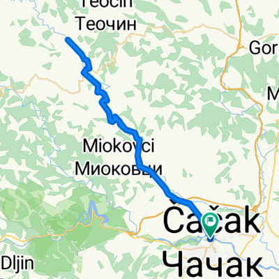
Cack-Slatinska banja-Samaila-Cacak
A cycling route starting in Čačak, Central Serbia, Serbia.
Overview
About this route
Biciklijada, Baco organizator, 45 ucesnika, asfalt, trening, BK Borac
- -:--
- Duration
- 56.3 km
- Distance
- 200 m
- Ascent
- 201 m
- Descent
- ---
- Avg. speed
- ---
- Avg. speed
Route quality
Waytypes & surfaces along the route
Waytypes
Busy road
44.2 km
(78 %)
Quiet road
8.1 km
(14 %)
Surfaces
Paved
12.4 km
(22 %)
Unpaved
0.1 km
(<1 %)
Asphalt
11.4 km
(20 %)
Paved (undefined)
0.9 km
(2 %)
Continue with Bikemap
Use, edit, or download this cycling route
You would like to ride Cack-Slatinska banja-Samaila-Cacak or customize it for your own trip? Here is what you can do with this Bikemap route:
Free features
- Save this route as favorite or in collections
- Copy & plan your own version of this route
- Sync your route with Garmin or Wahoo
Premium features
Free trial for 3 days, or one-time payment. More about Bikemap Premium.
- Navigate this route on iOS & Android
- Export a GPX / KML file of this route
- Create your custom printout (try it for free)
- Download this route for offline navigation
Discover more Premium features.
Get Bikemap PremiumFrom our community
Other popular routes starting in Čačak
- Cacak-Srezojeci-Kostunici-Miokovci-Cacak
- Distance
- 66.2 km
- Ascent
- 567 m
- Descent
- 565 m
- Location
- Čačak, Central Serbia, Serbia
- Cack-Slatinska banja-Samaila-Cacak
- Distance
- 56.3 km
- Ascent
- 200 m
- Descent
- 201 m
- Location
- Čačak, Central Serbia, Serbia
- Mrcajevci-Torlak-Brezovice-Mrcajevci
- Distance
- 49.3 km
- Ascent
- 717 m
- Descent
- 716 m
- Location
- Čačak, Central Serbia, Serbia
- Maraton Čačak
- Distance
- 156.8 km
- Ascent
- 1,352 m
- Descent
- 1,352 m
- Location
- Čačak, Central Serbia, Serbia
- Cacak-Cekovic
- Distance
- 51.6 km
- Ascent
- 278 m
- Descent
- 276 m
- Location
- Čačak, Central Serbia, Serbia
- Čačak-Koštunići-Tometino polje-Čačak
- Distance
- 95.4 km
- Ascent
- 871 m
- Descent
- 871 m
- Location
- Čačak, Central Serbia, Serbia
- Vranic - veliki krug
- Distance
- 9 km
- Ascent
- 139 m
- Descent
- 126 m
- Location
- Čačak, Central Serbia, Serbia
- Mrcajevci-Torlak-Brezovice-Kaona-Mrcajevci
- Distance
- 74.2 km
- Ascent
- 755 m
- Descent
- 755 m
- Location
- Čačak, Central Serbia, Serbia
Open it in the app