

trasa NA KOLE OD ŽENEVSKÉHO JEZERA K MATTERHORNU
A cycling route starting in Le Châtelard, Canton of Vaud, Switzerland.
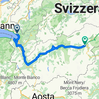
Overview
About this route
S větrem v zádech mezi alpskými velikány k nejkrásnějším místům švýcarského Wallisu na kole, ale i v pohorkách. Dávky si přitom určíte sami - základní trasa údolím Rhôny je pro "pohodáře", "sportovci" si mohou přidat kilometry stoupání v nádherných bočních údolích.
- -:--
- Duration
- 117.1 km
- Distance
- 1,240 m
- Ascent
- 1,130 m
- Descent
- ---
- Avg. speed
- ---
- Max. altitude

Route quality
Waytypes & surfaces along the route
Waytypes
Busy road
55.9 km
(48 %)
Quiet road
27.4 km
(23 %)
Surfaces
Paved
76.2 km
(65 %)
Unpaved
0.3 km
(<1 %)
Asphalt
74.4 km
(64 %)
Paved (undefined)
1.8 km
(2 %)
Route highlights
Points of interest along the route
Point of interest after 4.4 km
Chillon
Point of interest after 17.6 km
Aigle
Point of interest after 25.6 km
Bex, Švýcarsko
Point of interest after 69.1 km
Martigny
Point of interest after 99.1 km
Sion
Point of interest after 111.3 km
Crans-Montana
Continue with Bikemap
Use, edit, or download this cycling route
You would like to ride trasa NA KOLE OD ŽENEVSKÉHO JEZERA K MATTERHORNU or customize it for your own trip? Here is what you can do with this Bikemap route:
Free features
- Save this route as favorite or in collections
- Copy & plan your own version of this route
- Split it into stages to create a multi-day tour
- Sync your route with Garmin or Wahoo
Premium features
Free trial for 3 days, or one-time payment. More about Bikemap Premium.
- Navigate this route on iOS & Android
- Export a GPX / KML file of this route
- Create your custom printout (try it for free)
- Download this route for offline navigation
Discover more Premium features.
Get Bikemap PremiumFrom our community
Other popular routes starting in Le Châtelard
 Vers Chailly
- Distance
- 4 km
- Ascent
- 93 m
- Descent
- 93 m
- Location
- Le Châtelard, Canton of Vaud, Switzerland
 Chernex-Cerniaule
- Distance
- 9.5 km
- Ascent
- 768 m
- Descent
- 44 m
- Location
- Le Châtelard, Canton of Vaud, Switzerland
 RHONSKOU STEZKOU NA KOLE-www.nomad.cz
- Distance
- 181.2 km
- Ascent
- 1,311 m
- Descent
- 1,056 m
- Location
- Le Châtelard, Canton of Vaud, Switzerland
 Montreux - Rolle
- Distance
- 52.7 km
- Ascent
- 678 m
- Descent
- 681 m
- Location
- Le Châtelard, Canton of Vaud, Switzerland
 Clarens Sonchaux Caux
- Distance
- 29.7 km
- Ascent
- 896 m
- Descent
- 896 m
- Location
- Le Châtelard, Canton of Vaud, Switzerland
 Freiburg - Nizza in 4 Tagen/Tag 2: Montreux - Val d'Isère
- Distance
- 215.3 km
- Ascent
- 4,237 m
- Descent
- 2,784 m
- Location
- Le Châtelard, Canton of Vaud, Switzerland
 Clarens Villeneuve Chexbres et retour par les hauts
- Distance
- 75.2 km
- Ascent
- 1,709 m
- Descent
- 1,711 m
- Location
- Le Châtelard, Canton of Vaud, Switzerland
 Montreux - Chateau de Chillon
- Distance
- 25.2 km
- Ascent
- 927 m
- Descent
- 924 m
- Location
- Le Châtelard, Canton of Vaud, Switzerland
Open it in the app