

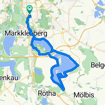
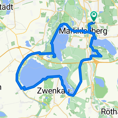
Dürrenbergrunde
A cycling route starting in Markkleeberg, Saxony, Germany.
Overview
About this route
- -:--
- Duration
- 84 km
- Distance
- 176 m
- Ascent
- 170 m
- Descent
- ---
- Avg. speed
- 150 m
- Max. altitude
Route quality
Waytypes & surfaces along the route
Waytypes
Road
27.7 km
(33 %)
Quiet road
18.5 km
(22 %)
Surfaces
Paved
72.2 km
(86 %)
Unpaved
2.5 km
(3 %)
Asphalt
71.4 km
(85 %)
Ground
1.7 km
(2 %)
Route highlights
Points of interest along the route
Point of interest after 14.4 km
RECHTS: 6km Abkürzung
Point of interest after 61.6 km
GERADEAUS: 9km Einsparung
Continue with Bikemap
Use, edit, or download this cycling route
You would like to ride Dürrenbergrunde or customize it for your own trip? Here is what you can do with this Bikemap route:
Free features
- Save this route as favorite or in collections
- Copy & plan your own version of this route
- Split it into stages to create a multi-day tour
- Sync your route with Garmin or Wahoo
Premium features
Free trial for 3 days, or one-time payment. More about Bikemap Premium.
- Navigate this route on iOS & Android
- Export a GPX / KML file of this route
- Create your custom printout (try it for free)
- Download this route for offline navigation
Discover more Premium features.
Get Bikemap PremiumFrom our community
Other popular routes starting in Markkleeberg
 Gustav-Meisel-Straße nach Ebersbrunn
- Distance
- 102.8 km
- Ascent
- 602 m
- Descent
- 341 m
- Location
- Markkleeberg, Saxony, Germany
 Siedlung Goldene Höhe, Markkleeberg nach Am Wolfswinkel, Markkleeberg
- Distance
- 14 km
- Ascent
- 106 m
- Descent
- 112 m
- Location
- Markkleeberg, Saxony, Germany
 Dürrenbergrunde
- Distance
- 84 km
- Ascent
- 176 m
- Descent
- 170 m
- Location
- Markkleeberg, Saxony, Germany
 Route Alt Connewitz
- Distance
- 40.1 km
- Ascent
- 162 m
- Descent
- 162 m
- Location
- Markkleeberg, Saxony, Germany
 Quer Feld ein in der Neuen Harth
- Distance
- 6.1 km
- Ascent
- 9 m
- Descent
- 8 m
- Location
- Markkleeberg, Saxony, Germany
 Route in Leipzig
- Distance
- 2.6 km
- Ascent
- 14 m
- Descent
- 7 m
- Location
- Markkleeberg, Saxony, Germany
 Am Wolfswinkel nach Am Wolfswinkel
- Distance
- 21 km
- Ascent
- 107 m
- Descent
- 148 m
- Location
- Markkleeberg, Saxony, Germany
 Helenenstraße nach Helenenstraße
- Distance
- 39.5 km
- Ascent
- 74 m
- Descent
- 74 m
- Location
- Markkleeberg, Saxony, Germany
Open it in the app