

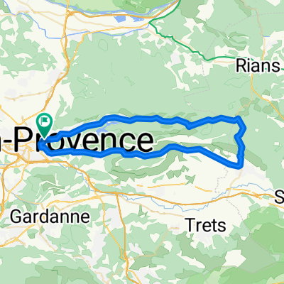
Aix-Eguilles-4Thermes-Coudoux-La Fare-Les Fourches-Lancon-Vautubierés-Roquefaveur-Aix
A cycling route starting in Aix-en-Provence, Provence-Alpes-Côte d'Azur Region, France.
Overview
About this route
Aix-Eguilles-4Thermes-Coudoux-La Fare-Les Fourches-Lancon-Vautubierés-Roquefaveur-Aix
- -:--
- Duration
- 70.2 km
- Distance
- 561 m
- Ascent
- 561 m
- Descent
- ---
- Avg. speed
- ---
- Max. altitude
Route quality
Waytypes & surfaces along the route
Waytypes
Road
30.9 km
(44 %)
Quiet road
12.6 km
(18 %)
Surfaces
Paved
35.1 km
(50 %)
Asphalt
34.4 km
(49 %)
Concrete
0.7 km
(1 %)
Undefined
35.1 km
(50 %)
Continue with Bikemap
Use, edit, or download this cycling route
You would like to ride Aix-Eguilles-4Thermes-Coudoux-La Fare-Les Fourches-Lancon-Vautubierés-Roquefaveur-Aix or customize it for your own trip? Here is what you can do with this Bikemap route:
Free features
- Save this route as favorite or in collections
- Copy & plan your own version of this route
- Sync your route with Garmin or Wahoo
Premium features
Free trial for 3 days, or one-time payment. More about Bikemap Premium.
- Navigate this route on iOS & Android
- Export a GPX / KML file of this route
- Create your custom printout (try it for free)
- Download this route for offline navigation
Discover more Premium features.
Get Bikemap PremiumFrom our community
Other popular routes starting in Aix-en-Provence
 Bibémus-bimont-doudon
- Distance
- 26.3 km
- Ascent
- 418 m
- Descent
- 421 m
- Location
- Aix-en-Provence, Provence-Alpes-Côte d'Azur Region, France
 Route in Aix-en-Provence
- Distance
- 28.7 km
- Ascent
- 461 m
- Descent
- 457 m
- Location
- Aix-en-Provence, Provence-Alpes-Côte d'Azur Region, France
 Marseille-5c: Rundtour Montagne Ste Victoire
- Distance
- 56.7 km
- Ascent
- 791 m
- Descent
- 791 m
- Location
- Aix-en-Provence, Provence-Alpes-Côte d'Azur Region, France
 Nord et ouest d'Aix en Provence
- Distance
- 39.6 km
- Ascent
- 294 m
- Descent
- 297 m
- Location
- Aix-en-Provence, Provence-Alpes-Côte d'Azur Region, France
 Tout De La Sainte Victoire
- Distance
- 54.4 km
- Ascent
- 984 m
- Descent
- 778 m
- Location
- Aix-en-Provence, Provence-Alpes-Côte d'Azur Region, France
 From Aix-en-Provence to Meyreuil
- Distance
- 22.9 km
- Ascent
- 437 m
- Descent
- 434 m
- Location
- Aix-en-Provence, Provence-Alpes-Côte d'Azur Region, France
 Descente marseille...
- Distance
- 71 km
- Ascent
- 534 m
- Descent
- 534 m
- Location
- Aix-en-Provence, Provence-Alpes-Côte d'Azur Region, France
 mercredi 11 mai
- Distance
- 25.9 km
- Ascent
- 261 m
- Descent
- 269 m
- Location
- Aix-en-Provence, Provence-Alpes-Côte d'Azur Region, France
Open it in the app