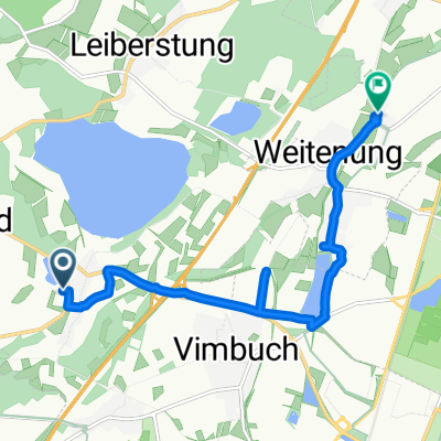
Badener Höhe
A cycling route starting in Ottenhofen, Baden-Wurttemberg, Germany.
Overview
About this route
Forest roads (40%), singletracks (20%), asphalt (30%) Beautiful singletracks, great views
- -:--
- Duration
- 35.2 km
- Distance
- 1,537 m
- Ascent
- 1,419 m
- Descent
- ---
- Avg. speed
- 994 m
- Max. altitude
Route quality
Waytypes & surfaces along the route
Waytypes
Track
21.8 km
(62 %)
Road
3.9 km
(11 %)
Surfaces
Paved
11.3 km
(32 %)
Unpaved
22.2 km
(63 %)
Gravel
20.8 km
(59 %)
Asphalt
10.9 km
(31 %)
Continue with Bikemap
Use, edit, or download this cycling route
You would like to ride Badener Höhe or customize it for your own trip? Here is what you can do with this Bikemap route:
Free features
- Save this route as favorite or in collections
- Copy & plan your own version of this route
- Sync your route with Garmin or Wahoo
Premium features
Free trial for 3 days, or one-time payment. More about Bikemap Premium.
- Navigate this route on iOS & Android
- Export a GPX / KML file of this route
- Create your custom printout (try it for free)
- Download this route for offline navigation
Discover more Premium features.
Get Bikemap PremiumFrom our community
Other popular routes starting in Ottenhofen
- BH2HS_1.ET
- Distance
- 106.6 km
- Ascent
- 676 m
- Descent
- 392 m
- Location
- Ottenhofen, Baden-Wurttemberg, Germany
- Einmal Rund um den Fremersberg
- Distance
- 20.4 km
- Ascent
- 246 m
- Descent
- 246 m
- Location
- Ottenhofen, Baden-Wurttemberg, Germany
- Da Mauerbergstraße 40, Baden-Baden a Yburg Burgruine 1, Baden-Baden
- Distance
- 4.7 km
- Ascent
- 342 m
- Descent
- 28 m
- Location
- Ottenhofen, Baden-Wurttemberg, Germany
- Weitenung Thea/Söllingen Weitenung
- Distance
- 28.3 km
- Ascent
- 12 m
- Descent
- 13 m
- Location
- Ottenhofen, Baden-Wurttemberg, Germany
- Weitenung Thea/Söllingen Weitenung
- Distance
- 28 km
- Ascent
- 8 m
- Descent
- 12 m
- Location
- Ottenhofen, Baden-Wurttemberg, Germany
- Badener Höhe
- Distance
- 35.2 km
- Ascent
- 1,537 m
- Descent
- 1,419 m
- Location
- Ottenhofen, Baden-Wurttemberg, Germany
- Route mittel
- Distance
- 29.2 km
- Ascent
- 71 m
- Descent
- 71 m
- Location
- Ottenhofen, Baden-Wurttemberg, Germany
- Yburg 26km
- Distance
- 25.9 km
- Ascent
- 648 m
- Descent
- 648 m
- Location
- Ottenhofen, Baden-Wurttemberg, Germany
Open it in the app