

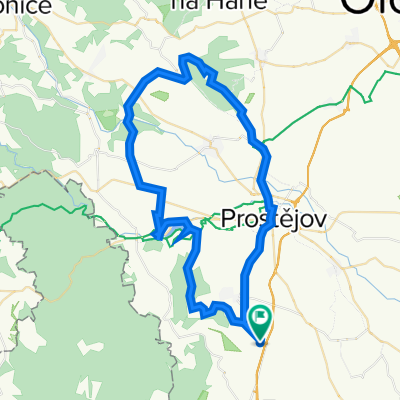
"Krátká na rozhlednu"
A cycling route starting in Otaslavice, Olomoucký kraj, Czechia.
Overview
About this route
- -:--
- Duration
- 7.1 km
- Distance
- 92 m
- Ascent
- 92 m
- Descent
- ---
- Avg. speed
- ---
- Max. altitude
Route quality
Waytypes & surfaces along the route
Waytypes
Road
3.6 km
(50 %)
Track
2.9 km
(40 %)
Surfaces
Paved
1.7 km
(24 %)
Unpaved
3.1 km
(44 %)
Mud
1.8 km
(25 %)
Asphalt
1.7 km
(24 %)
Route highlights
Points of interest along the route
Point of interest after 4 km
Rozhledna "Štátula"
Continue with Bikemap
Use, edit, or download this cycling route
You would like to ride "Krátká na rozhlednu" or customize it for your own trip? Here is what you can do with this Bikemap route:
Free features
- Save this route as favorite or in collections
- Copy & plan your own version of this route
- Sync your route with Garmin or Wahoo
Premium features
Free trial for 3 days, or one-time payment. More about Bikemap Premium.
- Navigate this route on iOS & Android
- Export a GPX / KML file of this route
- Create your custom printout (try it for free)
- Download this route for offline navigation
Discover more Premium features.
Get Bikemap PremiumFrom our community
Other popular routes starting in Otaslavice
 "Krátká na rozhlednu"
- Distance
- 7.1 km
- Ascent
- 92 m
- Descent
- 92 m
- Location
- Otaslavice, Olomoucký kraj, Czechia
 Smržické vandr (CT 110 km) 2011
- Distance
- 135.1 km
- Ascent
- 0 m
- Descent
- 0 m
- Location
- Otaslavice, Olomoucký kraj, Czechia
 Vranovická
- Distance
- 29.2 km
- Ascent
- 363 m
- Descent
- 356 m
- Location
- Otaslavice, Olomoucký kraj, Czechia
 Vranovice-kolem VP-Vranovice
- Distance
- 71 km
- Ascent
- 814 m
- Descent
- 814 m
- Location
- Otaslavice, Olomoucký kraj, Czechia
 Výlet do Modré
- Distance
- 113.8 km
- Ascent
- 1,283 m
- Descent
- 1,362 m
- Location
- Otaslavice, Olomoucký kraj, Czechia
 Vranovice-Kosíř-Vranovice
- Distance
- 54.8 km
- Ascent
- 569 m
- Descent
- 569 m
- Location
- Otaslavice, Olomoucký kraj, Czechia
 Smržická šlapka CT 94km (z Myslejovic)
- Distance
- 123.2 km
- Ascent
- 1,509 m
- Descent
- 1,595 m
- Location
- Otaslavice, Olomoucký kraj, Czechia
 Myslejovice-Podivice-Pustiměř-Ivanovice-Vrchoslavice-Klenovice-Prostějov-Myslejovice
- Distance
- 70.4 km
- Ascent
- 595 m
- Descent
- 577 m
- Location
- Otaslavice, Olomoucký kraj, Czechia
Open it in the app