

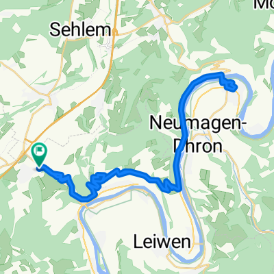
Strecke des IRT-BENEFIZ-RADTOUR
A cycling route starting in Bekond, Rhineland-Palatinate, Germany.
Overview
About this route
Die Route der IRT-BENEFIZ-RADTOUR führt Sie durch den malerischen IRT-Park. Starten Sie auf dem Gelände und fahren Sie durch wunderschöne Landschaften bis ins neue Erweiterungsgebiet. Nach diesem spannenden Abschnitt geht es wieder zurück zum Ausgangspunkt.
- 28 min
- Duration
- 7.7 km
- Distance
- 28 m
- Ascent
- 27 m
- Descent
- 16.3 km/h
- Avg. speed
- 210 m
- Max. altitude
Continue with Bikemap
Use, edit, or download this cycling route
You would like to ride Strecke des IRT-BENEFIZ-RADTOUR or customize it for your own trip? Here is what you can do with this Bikemap route:
Free features
- Save this route as favorite or in collections
- Copy & plan your own version of this route
- Sync your route with Garmin or Wahoo
Premium features
Free trial for 3 days, or one-time payment. More about Bikemap Premium.
- Navigate this route on iOS & Android
- Export a GPX / KML file of this route
- Create your custom printout (try it for free)
- Download this route for offline navigation
Discover more Premium features.
Get Bikemap PremiumFrom our community
Other popular routes starting in Bekond
 Route nach Hochkreuz 1, 54343 Föhren
- Distance
- 0.9 km
- Ascent
- 4 m
- Descent
- 0 m
- Location
- Bekond, Rhineland-Palatinate, Germany
 Moselstraße 55A, Bekond nach Moselstraße 55, Bekond
- Distance
- 25.6 km
- Ascent
- 487 m
- Descent
- 488 m
- Location
- Bekond, Rhineland-Palatinate, Germany
 Moselstraße 55A nach Moselstraße 55A
- Distance
- 37.2 km
- Ascent
- 634 m
- Descent
- 695 m
- Location
- Bekond, Rhineland-Palatinate, Germany
 Kieskaule
- Distance
- 11.5 km
- Ascent
- 96 m
- Descent
- 96 m
- Location
- Bekond, Rhineland-Palatinate, Germany
 Hammer Blick 🤠 – Aussichtsturm Fünf-Seen-Blick Runde von Föhren - Hammer Blick 🤠 – Aussichtsturm Fünf-Seen-Blick Runde von Föhren
- Distance
- 35.1 km
- Ascent
- 901 m
- Descent
- 902 m
- Location
- Bekond, Rhineland-Palatinate, Germany
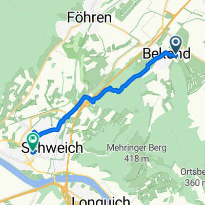
 Bekond - Schweich - Thörnicher Ritsch - Bekond
- Distance
- 24.2 km
- Ascent
- 187 m
- Descent
- 198 m
- Location
- Bekond, Rhineland-Palatinate, Germany
 Moselstraße, Bekond nach Im Ermesgraben, Schweich
- Distance
- 7.3 km
- Ascent
- 48 m
- Descent
- 125 m
- Location
- Bekond, Rhineland-Palatinate, Germany
 Bekond-Meulenwald-Quint-Schweich-Bekond
- Distance
- 31.7 km
- Ascent
- 673 m
- Descent
- 674 m
- Location
- Bekond, Rhineland-Palatinate, Germany
Open it in the app