

Berg und Tal unddrunter und drüber
A cycling route starting in Lonsee, Baden-Wurttemberg, Germany.
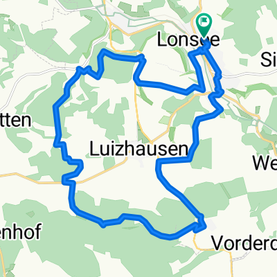
Overview
About this route
the route is great if you're training for a race of about 10 km. The descent is quite difficult since there's a tight 90-degree turn in the middle of the way, so have fun riding.
- -:--
- Duration
- 14.6 km
- Distance
- 346 m
- Ascent
- 346 m
- Descent
- ---
- Avg. speed
- ---
- Max. altitude
Continue with Bikemap
Use, edit, or download this cycling route
You would like to ride Berg und Tal unddrunter und drüber or customize it for your own trip? Here is what you can do with this Bikemap route:
Free features
- Save this route as favorite or in collections
- Copy & plan your own version of this route
- Sync your route with Garmin or Wahoo
Premium features
Free trial for 3 days, or one-time payment. More about Bikemap Premium.
- Navigate this route on iOS & Android
- Export a GPX / KML file of this route
- Create your custom printout (try it for free)
- Download this route for offline navigation
Discover more Premium features.
Get Bikemap PremiumFrom our community
Other popular routes starting in Lonsee
 Around Luiza
- Distance
- 19.9 km
- Ascent
- 360 m
- Descent
- 360 m
- Location
- Lonsee, Baden-Wurttemberg, Germany
 30km
30km- Distance
- 29.6 km
- Ascent
- 232 m
- Descent
- 232 m
- Location
- Lonsee, Baden-Wurttemberg, Germany
 Lonetal Quelle - Hürben - Eselsburg - Herbrechtingen
- Distance
- 44.3 km
- Ascent
- 213 m
- Descent
- 306 m
- Location
- Lonsee, Baden-Wurttemberg, Germany
 W-Town Steinbruch
- Distance
- 16.6 km
- Ascent
- 208 m
- Descent
- 208 m
- Location
- Lonsee, Baden-Wurttemberg, Germany
 Berg und Talbahn
- Distance
- 36 km
- Ascent
- 638 m
- Descent
- 638 m
- Location
- Lonsee, Baden-Wurttemberg, Germany
 Berg und Tal unddrunter und drüber
- Distance
- 14.6 km
- Ascent
- 346 m
- Descent
- 346 m
- Location
- Lonsee, Baden-Wurttemberg, Germany
 Luizhausen - Ulm Hbf
- Distance
- 21.7 km
- Ascent
- 53 m
- Descent
- 199 m
- Location
- Lonsee, Baden-Wurttemberg, Germany
 Hausrunde Julian
- Distance
- 13.8 km
- Ascent
- 263 m
- Descent
- 266 m
- Location
- Lonsee, Baden-Wurttemberg, Germany
Open it in the app