

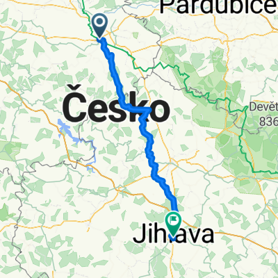
2. Etappe - Kolin to Brno - Friday 27th April
A cycling route starting in Kutná Hora, Central Bohemia, Czechia.
Overview
About this route
Start
Hotel Kreta
Prachňanská 88, 284 01 Kutná Hora
+420603874745
Finish
Hotel Rakovec
Rakovecká 13, 635 00 Brno
+420534001016
- -:--
- Duration
- 167 km
- Distance
- 1,071 m
- Ascent
- 1,073 m
- Descent
- ---
- Avg. speed
- ---
- Max. altitude

Route quality
Waytypes & surfaces along the route
Waytypes
Road
31.7 km
(19 %)
Quiet road
8.3 km
(5 %)
Surfaces
Paved
75.1 km
(45 %)
Asphalt
73.5 km
(44 %)
Paved (undefined)
1.7 km
(1 %)
Undefined
91.8 km
(55 %)
Route highlights
Points of interest along the route
Drinking water after 167 km
Drinking water after 167 km
Drinking water after 167 km
Continue with Bikemap
Use, edit, or download this cycling route
You would like to ride 2. Etappe - Kolin to Brno - Friday 27th April or customize it for your own trip? Here is what you can do with this Bikemap route:
Free features
- Save this route as favorite or in collections
- Copy & plan your own version of this route
- Split it into stages to create a multi-day tour
- Sync your route with Garmin or Wahoo
Premium features
Free trial for 3 days, or one-time payment. More about Bikemap Premium.
- Navigate this route on iOS & Android
- Export a GPX / KML file of this route
- Create your custom printout (try it for free)
- Download this route for offline navigation
Discover more Premium features.
Get Bikemap PremiumFrom our community
Other popular routes starting in Kutná Hora
 Palackého náměstí to Fibichova
- Distance
- 89.9 km
- Ascent
- 949 m
- Descent
- 752 m
- Location
- Kutná Hora, Central Bohemia, Czechia
 2. Etappe - Kolin to Brno - Friday 27th April
- Distance
- 167 km
- Ascent
- 1,071 m
- Descent
- 1,073 m
- Location
- Kutná Hora, Central Bohemia, Czechia
 Cyklo trasa po známých, nezmáných památkách
- Distance
- 45.9 km
- Ascent
- 505 m
- Descent
- 503 m
- Location
- Kutná Hora, Central Bohemia, Czechia
 Kutnohorská Fitness 20
- Distance
- 19.3 km
- Ascent
- 300 m
- Descent
- 320 m
- Location
- Kutná Hora, Central Bohemia, Czechia
 Lorecká, Kutná Hora až Jeneweinova, Kutná Hora
- Distance
- 7.4 km
- Ascent
- 442 m
- Descent
- 440 m
- Location
- Kutná Hora, Central Bohemia, Czechia
 Zmrzlinová do Miskovic
- Distance
- 10.7 km
- Ascent
- 129 m
- Descent
- 126 m
- Location
- Kutná Hora, Central Bohemia, Czechia
 Kutná Hora Praha
- Distance
- 91.1 km
- Ascent
- 608 m
- Descent
- 631 m
- Location
- Kutná Hora, Central Bohemia, Czechia
 Ferien tag 3
- Distance
- 55.5 km
- Ascent
- 159 m
- Descent
- 224 m
- Location
- Kutná Hora, Central Bohemia, Czechia
Open it in the app