

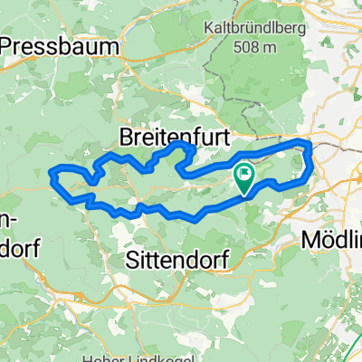
Parapluie - Kaltenleutgeben MTB
A cycling route starting in Kaltenleutgeben, Lower Austria, Austria.
Overview
About this route
- -:--
- Duration
- 32.8 km
- Distance
- 672 m
- Ascent
- 672 m
- Descent
- ---
- Avg. speed
- ---
- Max. altitude

Route quality
Waytypes & surfaces along the route
Waytypes
Track
21.3 km
(65 %)
Quiet road
4.9 km
(15 %)
Surfaces
Paved
10.8 km
(33 %)
Unpaved
19.7 km
(60 %)
Gravel
14.1 km
(43 %)
Asphalt
7.5 km
(23 %)
Continue with Bikemap
Use, edit, or download this cycling route
You would like to ride Parapluie - Kaltenleutgeben MTB or customize it for your own trip? Here is what you can do with this Bikemap route:
Free features
- Save this route as favorite or in collections
- Copy & plan your own version of this route
- Sync your route with Garmin or Wahoo
Premium features
Free trial for 3 days, or one-time payment. More about Bikemap Premium.
- Navigate this route on iOS & Android
- Export a GPX / KML file of this route
- Create your custom printout (try it for free)
- Download this route for offline navigation
Discover more Premium features.
Get Bikemap PremiumFrom our community
Other popular routes starting in Kaltenleutgeben
 Parapluie - EExtdd
- Distance
- 41 km
- Ascent
- 808 m
- Descent
- 808 m
- Location
- Kaltenleutgeben, Lower Austria, Austria
 Parapluie - Extdd
- Distance
- 35.8 km
- Ascent
- 739 m
- Descent
- 739 m
- Location
- Kaltenleutgeben, Lower Austria, Austria
 Wr. Hütte - Pappelteich-Strecke - Wr. Hütte
- Distance
- 25.5 km
- Ascent
- 542 m
- Descent
- 542 m
- Location
- Kaltenleutgeben, Lower Austria, Austria
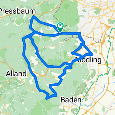
 Breitenfurt - Wienerwald - Ba Vöslau - Mödling
- Distance
- 65.6 km
- Ascent
- 993 m
- Descent
- 1,072 m
- Location
- Kaltenleutgeben, Lower Austria, Austria
 ride from Breitenfurt bei Wien to Vienna
- Distance
- 18.1 km
- Ascent
- 118 m
- Descent
- 280 m
- Location
- Kaltenleutgeben, Lower Austria, Austria
 Helenental
- Distance
- 66.1 km
- Ascent
- 779 m
- Descent
- 780 m
- Location
- Kaltenleutgeben, Lower Austria, Austria
 weitere hügelige Rennradrunde
- Distance
- 96.5 km
- Ascent
- 873 m
- Descent
- 873 m
- Location
- Kaltenleutgeben, Lower Austria, Austria
 Kaltenleutgeben-Lainzer TG
- Distance
- 41 km
- Ascent
- 865 m
- Descent
- 865 m
- Location
- Kaltenleutgeben, Lower Austria, Austria
Open it in the app