

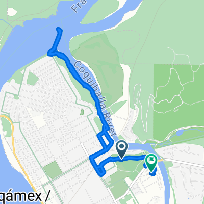
Hope to Sunshine Valley
A cycling route starting in Hope, British Columbia, Canada.
Overview
About this route
This was one very slow ride, as aside from the last kilometer or two, it was pretty much all uphill in the rain. Getting out of Hope was a climb on a very busy highway, which combines as both BC Highways 5 and 3 (and maybe National Highway 1 as well). Eventually, after a few kilometers, we exited the main highway onto Highway 3 and were overjoyed by the much lower level of traffic. (There was still more traffic and noise than we would have liked, but by comparison, it was much much better.) Throughout the entire ride today, there was good road shoulder, though at times on the latter part of the climbing, the shoulder could have been a little wider.
Due to low-hanging clouds, we couldn't see to much of the scenery, but what we could see was wonderful.
- 3 h 39 min
- Duration
- 23.5 km
- Distance
- 944 m
- Ascent
- 307 m
- Descent
- 6.4 km/h
- Avg. speed
- 731 m
- Max. altitude

Route photos


Continue with Bikemap
Use, edit, or download this cycling route
You would like to ride Hope to Sunshine Valley or customize it for your own trip? Here is what you can do with this Bikemap route:
Free features
- Save this route as favorite or in collections
- Copy & plan your own version of this route
- Sync your route with Garmin or Wahoo
Premium features
Free trial for 3 days, or one-time payment. More about Bikemap Premium.
- Navigate this route on iOS & Android
- Export a GPX / KML file of this route
- Create your custom printout (try it for free)
- Download this route for offline navigation
Discover more Premium features.
Get Bikemap PremiumFrom our community
Other popular routes starting in Hope
 End of Cross Canada Ride
- Distance
- 373.8 km
- Ascent
- 2,781 m
- Descent
- 2,806 m
- Location
- Hope, British Columbia, Canada
 Canada by Bike: Hope - Princeton
- Distance
- 132.8 km
- Ascent
- 1,774 m
- Descent
- 1,196 m
- Location
- Hope, British Columbia, Canada
 62210 Flood Hope Rd, Hope à 67354–67498 Tunnels Rd, Fraser Valley H
- Distance
- 13.1 km
- Ascent
- 395 m
- Descent
- 256 m
- Location
- Hope, British Columbia, Canada
 Hope Othello Nicola Valley Trail vom 29. September, 10:31
- Distance
- 6.3 km
- Ascent
- 343 m
- Descent
- 343 m
- Location
- Hope, British Columbia, Canada
 740 River Parade, Hope to 800 Kawkawa Lake Rd, Hope
- Distance
- 6.4 km
- Ascent
- 50 m
- Descent
- 49 m
- Location
- Hope, British Columbia, Canada
 Hope Manning
- Distance
- 147.5 km
- Ascent
- 1,942 m
- Descent
- 1,284 m
- Location
- Hope, British Columbia, Canada
 Hope to Sunshine Valley
- Distance
- 23.5 km
- Ascent
- 944 m
- Descent
- 307 m
- Location
- Hope, British Columbia, Canada
 Hope to Manning Park
- Distance
- 66.5 km
- Ascent
- 1,546 m
- Descent
- 376 m
- Location
- Hope, British Columbia, Canada
Open it in the app