
Views from the South Cycle Ride
A cycling route starting in Camberwell, England, United Kingdom.
Overview
About this route
Southwark Cyclists Healthy Ride
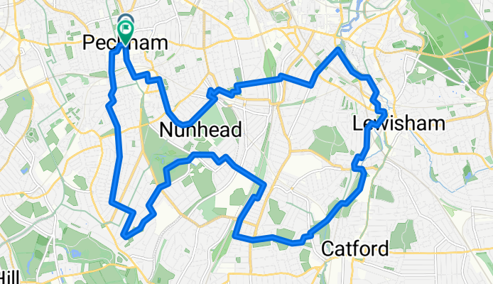
Start at Peckham Square, next to Peckham Library and Peckham Pulse Leisure Centre. 19km (11.5 mile) route: Peckham - Dawson's Heights - Blythe Hill - Telegraph Hill – Peckham. Coffee in Ladywell Fields. There are 3 significant hills to get to the viewpoints and a total of 184 m ascending which is more than we usually do. Mostly quiet streets, bits of path in parks and a section of Nat Route 21. Estimated time is 2.5 hours
- 1 h 11 min
- Duration
- 18.4 km
- Distance
- 148 m
- Ascent
- 145 m
- Descent
- 15.5 km/h
- Avg. speed
- 65 m
- Max. altitude
Route quality
Waytypes & surfaces along the route
Waytypes
Quiet road
10.1 km
(55 %)
Cycleway
3.7 km
(20 %)
Surfaces
Paved
14.4 km
(78 %)
Unpaved
0.4 km
(2 %)
Asphalt
13.8 km
(75 %)
Paved (undefined)
0.6 km
(3 %)
Continue with Bikemap
Use, edit, or download this cycling route
You would like to ride Views from the South Cycle Ride or customize it for your own trip? Here is what you can do with this Bikemap route:
Free features
- Save this route as favorite or in collections
- Copy & plan your own version of this route
- Sync your route with Garmin or Wahoo
Premium features
Free trial for 3 days, or one-time payment. More about Bikemap Premium.
- Navigate this route on iOS & Android
- Export a GPX / KML file of this route
- Create your custom printout (try it for free)
- Download this route for offline navigation
Discover more Premium features.
Get Bikemap PremiumFrom our community
Other popular routes starting in Camberwell
 Round the parks ride
- Distance
- 15.8 km
- Ascent
- 74 m
- Descent
- 73 m
- Location
- Camberwell, England, United Kingdom
 Ravensbourne and Wandle Circular
- Distance
- 51.6 km
- Ascent
- 167 m
- Descent
- 165 m
- Location
- Camberwell, England, United Kingdom
 Views from the South Cycle Ride
- Distance
- 18.4 km
- Ascent
- 148 m
- Descent
- 145 m
- Location
- Camberwell, England, United Kingdom
 Blackheath
- Distance
- 8.2 km
- Ascent
- 109 m
- Descent
- 80 m
- Location
- Camberwell, England, United Kingdom
 Purfleet RSPB Rainham Marshes
- Distance
- 32.5 km
- Ascent
- 76 m
- Descent
- 84 m
- Location
- Camberwell, England, United Kingdom
 Burgess Park to Holland Park and Brompton Cemetery
- Distance
- 24.3 km
- Ascent
- 85 m
- Descent
- 84 m
- Location
- Camberwell, England, United Kingdom
 Kent/Surrey borders route from East Dulwich
- Distance
- 66.9 km
- Ascent
- 632 m
- Descent
- 593 m
- Location
- Camberwell, England, United Kingdom
 Camberwell Purfleet Circular
- Distance
- 73 km
- Ascent
- 202 m
- Descent
- 203 m
- Location
- Camberwell, England, United Kingdom
Open it in the app