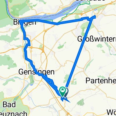
23.03.2012
A cycling route starting in Sprendlingen, Rhineland-Palatinate, Germany.
Overview
About this route
Der erste Teil der Strecke geht ab Neu-Bamberg überwiegend flach durch das wunderschöne Appellbachtal (auf dem Stück zwischen Hackenheim und Frei-Laubersheim geht auch ein Radweg neben der Bundestraße) Ab der Abzweigung in Oberhausen, wo man das Appelbachtal verläßt (von L400 auf L399) geht es bergauf - und dann geht die Strecke schön über die Höhe. Den Abschluß bildet nochmal eine kleine Bergwertung von Wallertheim über Gau-Weinheim nach Wolfsheim hoch - und ganz zum Abschluß rollt's nach Sprendlingen runter!
- -:--
- Duration
- 64 km
- Distance
- 434 m
- Ascent
- 433 m
- Descent
- ---
- Avg. speed
- ---
- Max. altitude
Route quality
Waytypes & surfaces along the route
Waytypes
Road
16.6 km
(26 %)
Track
5.8 km
(9 %)
Surfaces
Paved
49.9 km
(78 %)
Unpaved
2.6 km
(4 %)
Asphalt
48.6 km
(76 %)
Paved (undefined)
1.3 km
(2 %)
Continue with Bikemap
Use, edit, or download this cycling route
You would like to ride 23.03.2012 or customize it for your own trip? Here is what you can do with this Bikemap route:
Free features
- Save this route as favorite or in collections
- Copy & plan your own version of this route
- Sync your route with Garmin or Wahoo
Premium features
Free trial for 3 days, or one-time payment. More about Bikemap Premium.
- Navigate this route on iOS & Android
- Export a GPX / KML file of this route
- Create your custom printout (try it for free)
- Download this route for offline navigation
Discover more Premium features.
Get Bikemap PremiumFrom our community
Other popular routes starting in Sprendlingen
Gemütliche Route in Gau-Bickelheim- Distance
- 23 km
- Ascent
- 253 m
- Descent
- 252 m
- Location
- Sprendlingen, Rhineland-Palatinate, Germany
wissembourg- Distance
- 139 km
- Ascent
- 679 m
- Descent
- 629 m
- Location
- Sprendlingen, Rhineland-Palatinate, Germany
Recovered Route- Distance
- 50 km
- Ascent
- 19 m
- Descent
- 6 m
- Location
- Sprendlingen, Rhineland-Palatinate, Germany
23.03.2012- Distance
- 64 km
- Ascent
- 434 m
- Descent
- 433 m
- Location
- Sprendlingen, Rhineland-Palatinate, Germany
SaMi I- Distance
- 59.5 km
- Ascent
- 567 m
- Descent
- 419 m
- Location
- Sprendlingen, Rhineland-Palatinate, Germany
St Johanner-Straße 23, Sprendlingen nach Elisabethenstraße 15, Sprendlingen- Distance
- 57.6 km
- Ascent
- 241 m
- Descent
- 236 m
- Location
- Sprendlingen, Rhineland-Palatinate, Germany
16.06.2013- Distance
- 70.4 km
- Ascent
- 520 m
- Descent
- 520 m
- Location
- Sprendlingen, Rhineland-Palatinate, Germany
Sprendlingen via Neustadt nach Wiesloch- Distance
- 130.8 km
- Ascent
- 536 m
- Descent
- 479 m
- Location
- Sprendlingen, Rhineland-Palatinate, Germany
Open it in the app

