- 95.1 km
- 1,789 m
- 1,788 m
- Šumperk, Olomoucký kraj, Czechia
MTBackcountry kolem Šumperka
A cycling route starting in Šumperk, Olomoucký kraj, Czechia.
Overview
About this route
Nutritious MTB route around Šumperk. It mostly follows tourist paths approved by SHOCART. Besides challenging climbs and descents, it also includes playful singletracks and passes near several landmarks (City Rocks, Velké Losiny, Garnet Rock, Klein's Tomb, the ruins of Brníčko Castle, Háj Lookout Tower). About halfway through, it returns to Šumperk, making it easy to split into two stages.
Happy riding!
- -:--
- Duration
- 72.8 km
- Distance
- 1,515 m
- Ascent
- 1,519 m
- Descent
- ---
- Avg. speed
- ---
- Max. altitude
created this 16 years ago
Route highlights
Points of interest along the route

Point of interest after 7.2 km
Po zelené tz možno odbočit k vyhlídce Městské skály 675m.

Point of interest after 14.4 km
Zámek Velké Losiny.

Point of interest after 20.6 km
Kleinova hrobka.

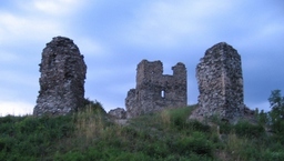
Point of interest after 49.4 km
Zřícenina hradu Brníčko.
Continue with Bikemap
Use, edit, or download this cycling route
You would like to ride MTBackcountry kolem Šumperka or customize it for your own trip? Here is what you can do with this Bikemap route:
Free features
- Save this route as favorite or in collections
- Copy & plan your own version of this route
- Sync your route with Garmin or Wahoo
Premium features
Free trial for 3 days, or one-time payment. More about Bikemap Premium.
- Navigate this route on iOS & Android
- Export a GPX / KML file of this route
- Create your custom printout (try it for free)
- Download this route for offline navigation
Discover more Premium features.
Get Bikemap PremiumFrom our community
Other popular routes starting in Šumperk
- SSMTB VKJ Rýmařovsko
- ou751der's VKJ 2016 den 1
- 95.9 km
- 2,129 m
- 1,557 m
- Šumperk, Olomoucký kraj, Czechia
- Šumperk-Oskava-Rabštejn-Šumperk
- 45.7 km
- 868 m
- 868 m
- Šumperk, Olomoucký kraj, Czechia
- Šumperk_Bohdikov_Severomoravska chata_Ruda_Sump
- 56.8 km
- 1,156 m
- 1,156 m
- Šumperk, Olomoucký kraj, Czechia
- Šumperk - Hněvkovské tunely - Hoštejn - Zábřeh - Nový Malín - Šumperk
- 61.1 km
- 391 m
- 392 m
- Šumperk, Olomoucký kraj, Czechia
- Grand Royal Tour De Jeseníky 2009
- 150.8 km
- 3,069 m
- 2,576 m
- Šumperk, Olomoucký kraj, Czechia
- aaaa
- 4 km
- 148 m
- 98 m
- Šumperk, Olomoucký kraj, Czechia
- MTBackcountry kolem Šumperka
- 72.8 km
- 1,515 m
- 1,519 m
- Šumperk, Olomoucký kraj, Czechia
Open it in the app


