Padang Pagar alam 2012
A cycling route starting in Pagar Alam, South Sumatra, Indonesia.
Overview
About this route
deuxième étape de la daigonale nord sud de Sumatra au départ de Banda Aceh
- -:--
- Duration
- 741 km
- Distance
- 1,711 m
- Ascent
- 2,400 m
- Descent
- ---
- Avg. speed
- ---
- Max. altitude
Continue with Bikemap
Use, edit, or download this cycling route
You would like to ride Padang Pagar alam 2012 or customize it for your own trip? Here is what you can do with this Bikemap route:
Free features
- Save this route as favorite or in collections
- Copy & plan your own version of this route
- Split it into stages to create a multi-day tour
- Sync your route with Garmin or Wahoo
Premium features
Free trial for 3 days, or one-time payment. More about Bikemap Premium.
- Navigate this route on iOS & Android
- Export a GPX / KML file of this route
- Create your custom printout (try it for free)
- Download this route for offline navigation
Discover more Premium features.
Get Bikemap PremiumFrom our community
Other popular routes starting in Pagar Alam
- Jalan Husly Marik to Jalan Mayjen S. Parman
- Distance
- 1 km
- Ascent
- 18 m
- Descent
- 17 m
- Location
- Pagar Alam, South Sumatra, Indonesia
- Route to X56V+4FG, Kecamatan Pagar Alam Selatan
- Distance
- 28.8 km
- Ascent
- 656 m
- Descent
- 675 m
- Location
- Pagar Alam, South Sumatra, Indonesia
- Sumatra 4 Par Bengkulu
- Distance
- 572.1 km
- Ascent
- 2,151 m
- Descent
- 1,689 m
- Location
- Pagar Alam, South Sumatra, Indonesia
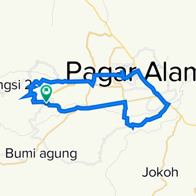
- X6MX+FXG to Jalan Sindang Raya
- Distance
- 13.8 km
- Ascent
- 198 m
- Descent
- 193 m
- Location
- Pagar Alam, South Sumatra, Indonesia
- Padang Pagar alam 2012
- Distance
- 741 km
- Ascent
- 1,711 m
- Descent
- 2,400 m
- Location
- Pagar Alam, South Sumatra, Indonesia
Open it in the app