

SP/TP Bike path route plan
A cycling route starting in Taringa, Queensland, Australia.
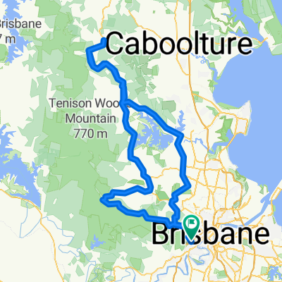
Overview
About this route
Ride from park opposite Indooroopilly Den, to Rocks Riverside Park.
- 53 min
- Duration
- 13.4 km
- Distance
- 141 m
- Ascent
- 142 m
- Descent
- 15.3 km/h
- Avg. speed
- 47 m
- Max. altitude
Route quality
Waytypes & surfaces along the route
Waytypes
Cycleway
13.4 km
(100 %)
Surfaces
Paved
13.4 km
(100 %)
Concrete
13.1 km
(98 %)
Asphalt
0.2 km
(2 %)
Continue with Bikemap
Use, edit, or download this cycling route
You would like to ride SP/TP Bike path route plan or customize it for your own trip? Here is what you can do with this Bikemap route:
Free features
- Save this route as favorite or in collections
- Copy & plan your own version of this route
- Sync your route with Garmin or Wahoo
Premium features
Free trial for 3 days, or one-time payment. More about Bikemap Premium.
- Navigate this route on iOS & Android
- Export a GPX / KML file of this route
- Create your custom printout (try it for free)
- Download this route for offline navigation
Discover more Premium features.
Get Bikemap PremiumFrom our community
Other popular routes starting in Taringa
 River Loop: Jindalee-Teneriffe
- Distance
- 35.4 km
- Ascent
- 179 m
- Descent
- 179 m
- Location
- Taringa, Queensland, Australia
 Nebo Samford Dayboro
- Distance
- 117 km
- Ascent
- 862 m
- Descent
- 859 m
- Location
- Taringa, Queensland, Australia
 bike tour from Mount Coot-Tha to Fig Tree Pocket
- Distance
- 18.7 km
- Ascent
- 390 m
- Descent
- 440 m
- Location
- Taringa, Queensland, Australia
 Mt Cootha finish with breakfast
- Distance
- 5.9 km
- Ascent
- 268 m
- Descent
- 272 m
- Location
- Taringa, Queensland, Australia
 Toowong, Mt Mee, Samford, Mt Nebo loop
- Distance
- 165.9 km
- Ascent
- 1,274 m
- Descent
- 1,271 m
- Location
- Taringa, Queensland, Australia
 28 Ada Street, Toowong to 30 Ada Street, Toowong
- Distance
- 10.9 km
- Ascent
- 0 m
- Descent
- 10 m
- Location
- Taringa, Queensland, Australia
 3 figures route
- Distance
- 67.9 km
- Ascent
- 449 m
- Descent
- 453 m
- Location
- Taringa, Queensland, Australia
 Western Brisbane 67 km River Loop
- Distance
- 67.3 km
- Ascent
- 759 m
- Descent
- 758 m
- Location
- Taringa, Queensland, Australia
Open it in the app