
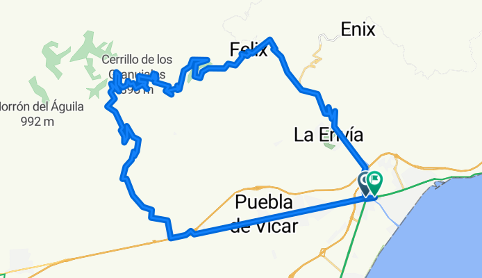
PARADOR-TARTEL-CARCAUZ-FELIX
A cycling route starting in Aguadulce, Andalusia, Spain.
Overview
About this route
EL PARADOR
EL VISO
PEÑÓN de BERNAL
TARTEL
RAMBLA CARCAUZ
FELIX
loop through La Envía
- -:--
- Duration
- 52.3 km
- Distance
- 1,383 m
- Ascent
- 1,380 m
- Descent
- ---
- Avg. speed
- ---
- Max. altitude

Route quality
Waytypes & surfaces along the route
Waytypes
Track
26.7 km
(51 %)
Road
7.3 km
(14 %)
Surfaces
Paved
11.5 km
(22 %)
Asphalt
11.5 km
(22 %)
Undefined
40.8 km
(78 %)
Route highlights
Points of interest along the route

Point of interest after 15.9 km
Subida por el Peñón de Bernal

Point of interest after 19.3 km
Fuente TARTEL [cota: 755 m]

Point of interest after 28.9 km
cruce de la Rambla Carcauz
Continue with Bikemap
Use, edit, or download this cycling route
You would like to ride PARADOR-TARTEL-CARCAUZ-FELIX or customize it for your own trip? Here is what you can do with this Bikemap route:
Free features
- Save this route as favorite or in collections
- Copy & plan your own version of this route
- Sync your route with Garmin or Wahoo
Premium features
Free trial for 3 days, or one-time payment. More about Bikemap Premium.
- Navigate this route on iOS & Android
- Export a GPX / KML file of this route
- Create your custom printout (try it for free)
- Download this route for offline navigation
Discover more Premium features.
Get Bikemap PremiumFrom our community
Other popular routes starting in Aguadulce
 PARADOR-TARTEL-CARCAUZ-FELIX
- Distance
- 52.3 km
- Ascent
- 1,383 m
- Descent
- 1,380 m
- Location
- Aguadulce, Andalusia, Spain
 4ª QUEDADA BTT EL PARADOR (15-05-2016)
- Distance
- 41.9 km
- Ascent
- 958 m
- Descent
- 958 m
- Location
- Aguadulce, Andalusia, Spain
 2ª QDD BTT EL PARADOR
- Distance
- 31.2 km
- Ascent
- 812 m
- Descent
- 812 m
- Location
- Aguadulce, Andalusia, Spain
 AGUADULCE-FELIX-Peñón de BERNAL
- Distance
- 38.8 km
- Ascent
- 909 m
- Descent
- 907 m
- Location
- Aguadulce, Andalusia, Spain
 AGUADULCE-VICAR-FELIX-CARCAUZ
- Distance
- 40.2 km
- Ascent
- 885 m
- Descent
- 882 m
- Location
- Aguadulce, Andalusia, Spain
 GRAN RUTA Roquetas-Alpujarra
- Distance
- 133 km
- Ascent
- 2,240 m
- Descent
- 2,242 m
- Location
- Aguadulce, Andalusia, Spain
 EL PARADOR-ENIX-Caseta Militares
- Distance
- 51.5 km
- Ascent
- 1,153 m
- Descent
- 1,156 m
- Location
- Aguadulce, Andalusia, Spain
 NUEVO MUNDO
- Distance
- 97.7 km
- Ascent
- 3,072 m
- Descent
- 2,794 m
- Location
- Aguadulce, Andalusia, Spain
Open it in the app