

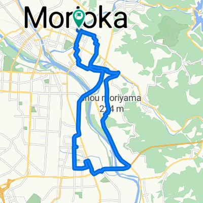
Tour du Japon - Jour 8-9 Hanayama - Funagata
A cycling route starting in Morioka, Iwate, Japan.
Overview
About this route
- 7 h 45 min
- Duration
- 118 km
- Distance
- 1,419 m
- Ascent
- 1,467 m
- Descent
- 15.2 km/h
- Avg. speed
- 407 m
- Max. altitude

Route quality
Waytypes & surfaces along the route
Waytypes
Cycleway
40.1 km
(34 %)
Quiet road
16.5 km
(14 %)
Surfaces
Paved
48.4 km
(41 %)
Paved (undefined)
37.8 km
(32 %)
Asphalt
10.6 km
(9 %)
Undefined
69.6 km
(59 %)
Continue with Bikemap
Use, edit, or download this cycling route
You would like to ride Tour du Japon - Jour 8-9 Hanayama - Funagata or customize it for your own trip? Here is what you can do with this Bikemap route:
Free features
- Save this route as favorite or in collections
- Copy & plan your own version of this route
- Split it into stages to create a multi-day tour
- Sync your route with Garmin or Wahoo
Premium features
Free trial for 3 days, or one-time payment. More about Bikemap Premium.
- Navigate this route on iOS & Android
- Export a GPX / KML file of this route
- Create your custom printout (try it for free)
- Download this route for offline navigation
Discover more Premium features.
Get Bikemap PremiumFrom our community
Other popular routes starting in Morioka
 本宮6丁目5-2, 盛岡市 to 本宮6丁目5-2, 盛岡市
- Distance
- 23.4 km
- Ascent
- 195 m
- Descent
- 194 m
- Location
- Morioka, Iwate, Japan
 1丁目 まで1丁目
- Distance
- 17.4 km
- Ascent
- 273 m
- Descent
- 321 m
- Location
- Morioka, Iwate, Japan
 盛岡市〜奥州市
- Distance
- 74 km
- Ascent
- 215 m
- Descent
- 290 m
- Location
- Morioka, Iwate, Japan
 1丁目 まで1丁目
- Distance
- 18.4 km
- Ascent
- 397 m
- Descent
- 450 m
- Location
- Morioka, Iwate, Japan
 12-23, Midorigaoka 1-Chōme, Morioka to Miyacho 1-Chōme, Miyako
- Distance
- 93.9 km
- Ascent
- 758 m
- Descent
- 912 m
- Location
- Morioka, Iwate, Japan
 hachinohehe
- Distance
- 116.7 km
- Ascent
- 1,631 m
- Descent
- 1,754 m
- Location
- Morioka, Iwate, Japan
 Route Length of Japan Morioka-Aomori
- Distance
- 232.2 km
- Ascent
- 3,132 m
- Descent
- 3,263 m
- Location
- Morioka, Iwate, Japan
 本宮6丁目5-2, 盛岡市 to 本宮6丁目4-16, 盛岡市
- Distance
- 26.8 km
- Ascent
- 75 m
- Descent
- 75 m
- Location
- Morioka, Iwate, Japan
Open it in the app