Rund um den Truppenübungsplatz Hohenfels
A cycling route starting in Ensdorf, Bavaria, Germany.
Overview
About this route
Rundfahrt um den Truppenübungsplatz Hohenfels. Von Amberg das Vilstal bis Schmidmühlen, dann auf dem Radweg weiter nach Rohrbach. Von Rohrbach nach Hohenfels auf dem Radweg. Von Hohenfels Richtung Parsberg bei Hörmannsdorf abbiegen weiter Richtung Sankt Colomann. Über Habsberg, Nattershofen, Sankt Lampert nach Kastl. Von Kastl über Giggelsberg nach Ursensollen. Von Ursensollen über Weiherzant wieder nach Amberg.
- -:--
- Duration
- 99.3 km
- Distance
- 1,131 m
- Ascent
- 1,066 m
- Descent
- ---
- Avg. speed
- 596 m
- Avg. speed
Route quality
Waytypes & surfaces along the route
Waytypes
Busy road
33.3 km
(34 %)
Road
24.7 km
(25 %)
Surfaces
Paved
78.4 km
(79 %)
Unpaved
4.7 km
(5 %)
Asphalt
75.3 km
(76 %)
Gravel
3.8 km
(4 %)
Continue with Bikemap
Use, edit, or download this cycling route
You would like to ride Rund um den Truppenübungsplatz Hohenfels or customize it for your own trip? Here is what you can do with this Bikemap route:
Free features
- Save this route as favorite or in collections
- Copy & plan your own version of this route
- Sync your route with Garmin or Wahoo
Premium features
Free trial for 3 days, or one-time payment. More about Bikemap Premium.
- Navigate this route on iOS & Android
- Export a GPX / KML file of this route
- Create your custom printout (try it for free)
- Download this route for offline navigation
Discover more Premium features.
Get Bikemap PremiumFrom our community
Other popular routes starting in Ensdorf
- Freihöls- Amberger Runde
- Distance
- 40.4 km
- Ascent
- 266 m
- Descent
- 265 m
- Location
- Ensdorf, Bavaria, Germany
- Testrunde zur challenge-Radrunde
- Distance
- 161 km
- Ascent
- 746 m
- Descent
- 727 m
- Location
- Ensdorf, Bavaria, Germany
- Dornberg-Wiefelsdorf-Schwarzenfeld-Amberg
- Distance
- 69.4 km
- Ascent
- 546 m
- Descent
- 548 m
- Location
- Ensdorf, Bavaria, Germany
- Hirschwaldstraße 4, Ensdorf nach Hirschwaldstraße 4, Ensdorf
- Distance
- 8.7 km
- Ascent
- 227 m
- Descent
- 227 m
- Location
- Ensdorf, Bavaria, Germany
- Jeding-Amberger Runde
- Distance
- 43.1 km
- Ascent
- 251 m
- Descent
- 250 m
- Location
- Ensdorf, Bavaria, Germany
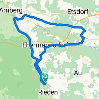
- Test der Kallmünz Tria-Strecke
- Distance
- 73.4 km
- Ascent
- 547 m
- Descent
- 558 m
- Location
- Ensdorf, Bavaria, Germany
- Route nach Burglengenfeld und retour
- Distance
- 40.6 km
- Ascent
- 419 m
- Descent
- 419 m
- Location
- Ensdorf, Bavaria, Germany
- Langdistanz Trainingsfahrt
- Distance
- 145.6 km
- Ascent
- 666 m
- Descent
- 668 m
- Location
- Ensdorf, Bavaria, Germany
Open it in the app