
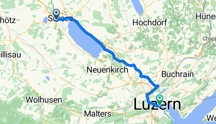
E2: Sursee - Luzern
A cycling route starting in Sursee, Canton of Lucerne, Switzerland.
Overview
About this route
Stage 2 from Basel to Chiasso
Sursee via Sempach, Rothenburg to Lucerne
(Part of national cycling route No. 3)
- -:--
- Duration
- 27 km
- Distance
- 136 m
- Ascent
- 208 m
- Descent
- ---
- Avg. speed
- ---
- Max. altitude
Route quality
Waytypes & surfaces along the route
Waytypes
Road
7.6 km
(28 %)
Cycleway
4.1 km
(15 %)
Surfaces
Paved
21.4 km
(79 %)
Unpaved
0.3 km
(1 %)
Asphalt
21.1 km
(78 %)
Paved (undefined)
0.3 km
(1 %)
Continue with Bikemap
Use, edit, or download this cycling route
You would like to ride E2: Sursee - Luzern or customize it for your own trip? Here is what you can do with this Bikemap route:
Free features
- Save this route as favorite or in collections
- Copy & plan your own version of this route
- Sync your route with Garmin or Wahoo
Premium features
Free trial for 3 days, or one-time payment. More about Bikemap Premium.
- Navigate this route on iOS & Android
- Export a GPX / KML file of this route
- Create your custom printout (try it for free)
- Download this route for offline navigation
Discover more Premium features.
Get Bikemap PremiumFrom our community
Other popular routes starting in Sursee
 Hasenwarte-Leidenberg-Mauensee
- Distance
- 14.3 km
- Ascent
- 257 m
- Descent
- 257 m
- Location
- Sursee, Canton of Lucerne, Switzerland
 Sempachersee
- Distance
- 19.8 km
- Ascent
- 66 m
- Descent
- 60 m
- Location
- Sursee, Canton of Lucerne, Switzerland
 Grosswangen-Ostergau-Höhewald-Schötz-Mauensee
- Distance
- 43.1 km
- Ascent
- 570 m
- Descent
- 570 m
- Location
- Sursee, Canton of Lucerne, Switzerland
 Biketour Sursee-Menzberg-Willisau-Sursee
- Distance
- 50.3 km
- Ascent
- 1,061 m
- Descent
- 1,059 m
- Location
- Sursee, Canton of Lucerne, Switzerland
 E2: Sursee - Luzern
- Distance
- 27 km
- Ascent
- 136 m
- Descent
- 208 m
- Location
- Sursee, Canton of Lucerne, Switzerland
 Sursee - Sempach - Hochdorf - Strälingen - Römerswil - Sursee
- Distance
- 47.9 km
- Ascent
- 583 m
- Descent
- 567 m
- Location
- Sursee, Canton of Lucerne, Switzerland
 Tannberg-Diegenstal-Geuensee
- Distance
- 17.5 km
- Ascent
- 380 m
- Descent
- 380 m
- Location
- Sursee, Canton of Lucerne, Switzerland
 Sempacher See - Kapellenweg LU/ eine "Himmlische Tour"!
- Distance
- 48.6 km
- Ascent
- 538 m
- Descent
- 541 m
- Location
- Sursee, Canton of Lucerne, Switzerland
Open it in the app