

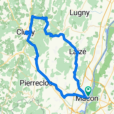
maconnais 80 km
A cycling route starting in Saint-Laurent-sur-Saône, Auvergne-Rhône-Alpes, France.
Overview
About this route
Mâcon Tramayes Sancé after work in the evening for training with hills
- -:--
- Duration
- 77.5 km
- Distance
- 1,081 m
- Ascent
- 1,058 m
- Descent
- ---
- Avg. speed
- ---
- Max. altitude
Route quality
Waytypes & surfaces along the route
Waytypes
Road
31 km
(40 %)
Quiet road
10.8 km
(14 %)
Surfaces
Paved
16.3 km
(21 %)
Asphalt
16.3 km
(21 %)
Undefined
61.2 km
(79 %)
Continue with Bikemap
Use, edit, or download this cycling route
You would like to ride maconnais 80 km or customize it for your own trip? Here is what you can do with this Bikemap route:
Free features
- Save this route as favorite or in collections
- Copy & plan your own version of this route
- Sync your route with Garmin or Wahoo
Premium features
Free trial for 3 days, or one-time payment. More about Bikemap Premium.
- Navigate this route on iOS & Android
- Export a GPX / KML file of this route
- Create your custom printout (try it for free)
- Download this route for offline navigation
Discover more Premium features.
Get Bikemap PremiumFrom our community
Other popular routes starting in Saint-Laurent-sur-Saône
 J4 A/B RC2 MIPIM 2018
- Distance
- 121.7 km
- Ascent
- 340 m
- Descent
- 366 m
- Location
- Saint-Laurent-sur-Saône, Auvergne-Rhône-Alpes, France
 maconnais 80 km
- Distance
- 77.5 km
- Ascent
- 1,081 m
- Descent
- 1,058 m
- Location
- Saint-Laurent-sur-Saône, Auvergne-Rhône-Alpes, France
 28 Rue Jean Jaurès, Saint-Laurent-sur-Saône naar Malay
- Distance
- 93 km
- Ascent
- 4,282 m
- Descent
- 4,255 m
- Location
- Saint-Laurent-sur-Saône, Auvergne-Rhône-Alpes, France
 Mâcon - Chalon-sur-Saône
- Distance
- 62.2 km
- Ascent
- 42 m
- Descent
- 33 m
- Location
- Saint-Laurent-sur-Saône, Auvergne-Rhône-Alpes, France
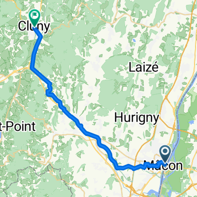 Saint-Laurent-sur-Saône - Cluny
- Distance
- 26.6 km
- Ascent
- 298 m
- Descent
- 234 m
- Location
- Saint-Laurent-sur-Saône, Auvergne-Rhône-Alpes, France
 Verdun-sur-le-Doubs - Salaise-sur-Sanne
- Distance
- 304.2 km
- Ascent
- 2,241 m
- Descent
- 2,147 m
- Location
- Saint-Laurent-sur-Saône, Auvergne-Rhône-Alpes, France
 Mâcon - Voie Verte - Cluny - Donzy - Hurigny - Mâcon
- Distance
- 64.1 km
- Ascent
- 1,009 m
- Descent
- 1,009 m
- Location
- Saint-Laurent-sur-Saône, Auvergne-Rhône-Alpes, France
 Saint-Martin-Belle-Roche - Lyon
- Distance
- 82.6 km
- Ascent
- 256 m
- Descent
- 262 m
- Location
- Saint-Laurent-sur-Saône, Auvergne-Rhône-Alpes, France
Open it in the app