
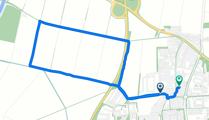
Rennweg 47, Erding nach Franz-Brombach-Straße 11-13, Erding
A cycling route starting in Erding, Bavaria, Germany.
Overview
About this route
- 52 min
- Duration
- 3.9 km
- Distance
- 24 m
- Ascent
- 28 m
- Descent
- 4.5 km/h
- Avg. speed
- 471 m
- Avg. speed

Route quality
Waytypes & surfaces along the route
Waytypes
Track
2.9 km
(74 %)
Quiet road
0.4 km
(11 %)
Surfaces
Paved
1.7 km
(44 %)
Unpaved
1.9 km
(49 %)
Asphalt
1.7 km
(42 %)
Pebblestone
1.1 km
(28 %)
Continue with Bikemap
Use, edit, or download this cycling route
You would like to ride Rennweg 47, Erding nach Franz-Brombach-Straße 11-13, Erding or customize it for your own trip? Here is what you can do with this Bikemap route:
Free features
- Save this route as favorite or in collections
- Copy & plan your own version of this route
- Sync your route with Garmin or Wahoo
Premium features
Free trial for 3 days, or one-time payment. More about Bikemap Premium.
- Navigate this route on iOS & Android
- Export a GPX / KML file of this route
- Create your custom printout (try it for free)
- Download this route for offline navigation
Discover more Premium features.
Get Bikemap PremiumFrom our community
Other popular routes starting in Erding
 Erding südwest
- Distance
- 30.1 km
- Ascent
- 75 m
- Descent
- 80 m
- Location
- Erding, Bavaria, Germany
 Erding - Skulp Tour 3
- Distance
- 77.5 km
- Ascent
- 248 m
- Descent
- 238 m
- Location
- Erding, Bavaria, Germany
 MTB Eschlbach
- Distance
- 31 km
- Ascent
- 209 m
- Descent
- 210 m
- Location
- Erding, Bavaria, Germany
 Erding-Walpertskirchen-Erding.gpx
- Distance
- 25.6 km
- Ascent
- 66 m
- Descent
- 63 m
- Location
- Erding, Bavaria, Germany
 Flughafenrunde
- Distance
- 39.1 km
- Ascent
- 40 m
- Descent
- 49 m
- Location
- Erding, Bavaria, Germany
 Trainingstour 1
- Distance
- 43.2 km
- Ascent
- 143 m
- Descent
- 143 m
- Location
- Erding, Bavaria, Germany
 Rund um den Ebersberger Forst
- Distance
- 90.3 km
- Ascent
- 346 m
- Descent
- 346 m
- Location
- Erding, Bavaria, Germany
 Rund um den Flughafen
- Distance
- 51.2 km
- Ascent
- 68 m
- Descent
- 69 m
- Location
- Erding, Bavaria, Germany
Open it in the app