

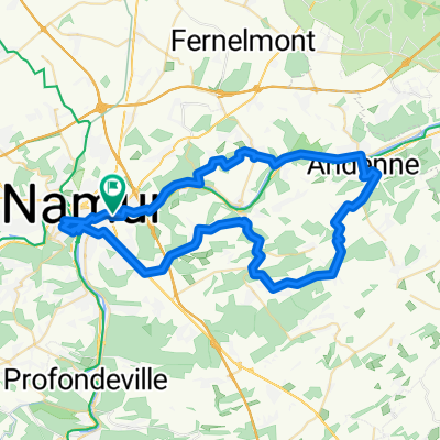
Namen citadel
A cycling route starting in Namur, Wallonia, Belgium.
Overview
About this route
- -:--
- Duration
- 59.2 km
- Distance
- 674 m
- Ascent
- 673 m
- Descent
- ---
- Avg. speed
- ---
- Max. altitude

Route quality
Waytypes & surfaces along the route
Waytypes
Busy road
27.5 km
(46 %)
Quiet road
14 km
(24 %)
Surfaces
Paved
30.6 km
(52 %)
Unpaved
0 km
(<1 %)
Asphalt
26.9 km
(45 %)
Paved (undefined)
3.1 km
(5 %)
Route highlights
Points of interest along the route
Point of interest after 8.1 km
Barrière de Bayet (193m) Hoogteverschil : 108m Lengte : 1.6 km Gem. steiging : 6.8%
Point of interest after 9.8 km
Les Carrières Montigny (200m)
Point of interest after 22.1 km
Côte de Peu d'Eau 1 (222m) Hoogteverschil : 142m Lengte : 2.7 km Gem. stijging : 5.3%
Point of interest after 24.2 km
Côte de Groynne (240m) Hoogteverschil : 160m Lengte : 2.7 km Gem. stijging : 5.9%
Point of interest after 27.6 km
Côte de Haut-Bois (253m) Hoogteverschil : 68m Lengte : 1.6 km Gem. stijging : 4.3%
Point of interest after 39 km
Côte de Maizeret (182m) Hoogteverschil : 101m Lengte : 1.5 km Gem. stijging : 6.7%
Point of interest after 52.5 km
Route Merveilleuse (190m) Hoogteverschil : 107m Lengte : 2 km Gem. stijging : 5.4%
Point of interest after 53.6 km
La Citadelle (211m)
Continue with Bikemap
Use, edit, or download this cycling route
You would like to ride Namen citadel or customize it for your own trip? Here is what you can do with this Bikemap route:
Free features
- Save this route as favorite or in collections
- Copy & plan your own version of this route
- Sync your route with Garmin or Wahoo
Premium features
Free trial for 3 days, or one-time payment. More about Bikemap Premium.
- Navigate this route on iOS & Android
- Export a GPX / KML file of this route
- Create your custom printout (try it for free)
- Download this route for offline navigation
Discover more Premium features.
Get Bikemap PremiumFrom our community
Other popular routes starting in Namur
 Chemin des Mélèzes 49, Namur to Chemin des Mélèzes 49, Namur
- Distance
- 11.1 km
- Ascent
- 554 m
- Descent
- 564 m
- Location
- Namur, Wallonia, Belgium
 Meuse / Namur
- Distance
- 18.2 km
- Ascent
- 139 m
- Descent
- 139 m
- Location
- Namur, Wallonia, Belgium
 La Condruzienne, Belgium
- Distance
- 380.6 km
- Ascent
- 7,439 m
- Descent
- 7,438 m
- Location
- Namur, Wallonia, Belgium
 Namur nach Lüttich
- Distance
- 71.7 km
- Ascent
- 149 m
- Descent
- 168 m
- Location
- Namur, Wallonia, Belgium
 Namen citadel
- Distance
- 59.2 km
- Ascent
- 674 m
- Descent
- 673 m
- Location
- Namur, Wallonia, Belgium
 namur sanson wierde dave
- Distance
- 37.9 km
- Ascent
- 215 m
- Descent
- 215 m
- Location
- Namur, Wallonia, Belgium
 Itinéraire facile en Namur
- Distance
- 32.1 km
- Ascent
- 502 m
- Descent
- 504 m
- Location
- Namur, Wallonia, Belgium
 Wépion1
- Distance
- 28.5 km
- Ascent
- 229 m
- Descent
- 229 m
- Location
- Namur, Wallonia, Belgium
Open it in the app