

Chiemgau: Bergen --> Hochfelln
A cycling route starting in Bergen, Bavaria, Germany.
Overview
About this route
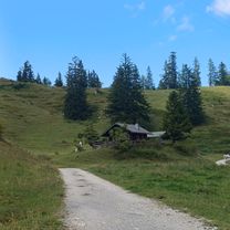
Schöner Panormamaanstieg von Bergen Richtung Hochfelln
- -:--
- Duration
- 4.7 km
- Distance
- 656 m
- Ascent
- 80 m
- Descent
- ---
- Avg. speed
- ---
- Max. altitude

Continue with Bikemap
Use, edit, or download this cycling route
You would like to ride Chiemgau: Bergen --> Hochfelln or customize it for your own trip? Here is what you can do with this Bikemap route:
Free features
- Save this route as favorite or in collections
- Copy & plan your own version of this route
- Sync your route with Garmin or Wahoo
Premium features
Free trial for 3 days, or one-time payment. More about Bikemap Premium.
- Navigate this route on iOS & Android
- Export a GPX / KML file of this route
- Create your custom printout (try it for free)
- Download this route for offline navigation
Discover more Premium features.
Get Bikemap PremiumFrom our community
Other popular routes starting in Bergen
 Bründling Alm Runde Nr 66
- Distance
- 18.3 km
- Ascent
- 882 m
- Descent
- 909 m
- Location
- Bergen, Bavaria, Germany
 Panoramarunde_active_Bergen
- Distance
- 20.7 km
- Ascent
- 738 m
- Descent
- 738 m
- Location
- Bergen, Bavaria, Germany
 Koaßa Genußrunde
- Distance
- 91.7 km
- Ascent
- 679 m
- Descent
- 698 m
- Location
- Bergen, Bavaria, Germany
 Chiemseerundfahrt zum Herrentag
- Distance
- 90 km
- Ascent
- 171 m
- Descent
- 174 m
- Location
- Bergen, Bavaria, Germany
 Hochfelln Moser
- Distance
- 21.5 km
- Ascent
- 1,022 m
- Descent
- 1,020 m
- Location
- Bergen, Bavaria, Germany
 Bergen-Kochel
- Distance
- 164.9 km
- Ascent
- 1,520 m
- Descent
- 1,493 m
- Location
- Bergen, Bavaria, Germany
 Bründlingalm
- Distance
- 17.5 km
- Ascent
- 666 m
- Descent
- 663 m
- Location
- Bergen, Bavaria, Germany
 EU22 Day 4 Bergen
- Distance
- 52.8 km
- Ascent
- 644 m
- Descent
- 521 m
- Location
- Bergen, Bavaria, Germany
Open it in the app