

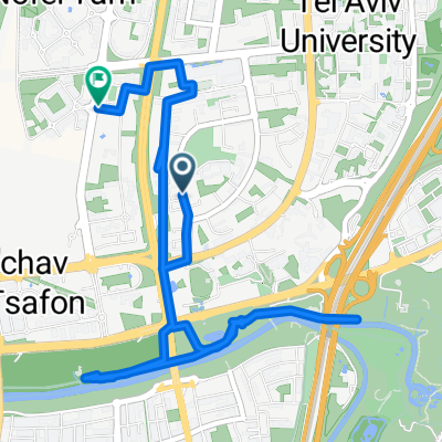
481 כביש, רמת גן to רח׳ ביאליק 26, רמת גן
A cycling route starting in Ramat Gan, Tel Aviv, Israel.
Overview
About this route
- 1 h 33 min
- Duration
- 16 km
- Distance
- 113 m
- Ascent
- 88 m
- Descent
- 10.3 km/h
- Avg. speed
- 59 m
- Max. altitude
Continue with Bikemap
Use, edit, or download this cycling route
You would like to ride 481 כביש, רמת גן to רח׳ ביאליק 26, רמת גן or customize it for your own trip? Here is what you can do with this Bikemap route:
Free features
- Save this route as favorite or in collections
- Copy & plan your own version of this route
- Sync your route with Garmin or Wahoo
Premium features
Free trial for 3 days, or one-time payment. More about Bikemap Premium.
- Navigate this route on iOS & Android
- Export a GPX / KML file of this route
- Create your custom printout (try it for free)
- Download this route for offline navigation
Discover more Premium features.
Get Bikemap PremiumFrom our community
Other popular routes starting in Ramat Gan
 הרב קוסובסקי 69, תל אביב יפו to הרב קוסובסקי 69, תל אביב יפו
- Distance
- 14.5 km
- Ascent
- 38 m
- Descent
- 37 m
- Location
- Ramat Gan, Tel Aviv, Israel
 גני יהושע נמל תל אביב בדיקה
- Distance
- 7.5 km
- Ascent
- 26 m
- Descent
- 28 m
- Location
- Ramat Gan, Tel Aviv, Israel
 Snail-like route in Ramat Gan
- Distance
- 16 km
- Ascent
- 429 m
- Descent
- 426 m
- Location
- Ramat Gan, Tel Aviv, Israel
 סובב טורקי 2018
- Distance
- 20.9 km
- Ascent
- 59 m
- Descent
- 43 m
- Location
- Ramat Gan, Tel Aviv, Israel
 Short ride from בני ברק to גבעתיים
- Distance
- 1.8 km
- Ascent
- 33 m
- Descent
- 0 m
- Location
- Ramat Gan, Tel Aviv, Israel
 Fast ride
- Distance
- 7.9 km
- Ascent
- 32 m
- Descent
- 78 m
- Location
- Ramat Gan, Tel Aviv, Israel
 homework
- Distance
- 15.8 km
- Ascent
- 62 m
- Descent
- 77 m
- Location
- Ramat Gan, Tel Aviv, Israel
 Route from Israel National Trail, Ramat Gan
- Distance
- 5.6 km
- Ascent
- 57 m
- Descent
- 68 m
- Location
- Ramat Gan, Tel Aviv, Israel
Open it in the app