
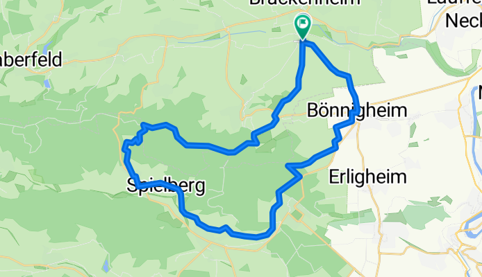


Route zu Waldschenke Hörnle
- 19.1 km
- 467 m
- 397 m
- Brackenheim, Baden-Wurttemberg, Germany
A cycling route starting in Brackenheim, Baden-Wurttemberg, Germany.
Overview
Botenheim – Spielberg 15.5 km
The tour starts in the center of Botenheim. Follow "Bönnigheimer Straße" heading towards Bönnigheim, leaving the town.
At the town exit roundabout, a bike path begins on the left, running parallel to the district road leading to Bönnigheim. At the town entrance, go straight along the main road into town.
At the end of "Meimsheimer Straße," continue straight into the old town. Turn right onto "Michaelsbergstraße," then left downhill on the main road, and after the bridge turn right onto "Forststraße" exiting the town.
At the T-junction after the tennis courts, turn left; at the next four-way intersection, continue straight uphill along the vineyard.
At the hilltop, continue straight downhill along the orchard meadow. In the valley, pass a house on the right and enter the farm road. Follow it, first in the valley, then gently uphill into the forest. Go straight over the main road, then turn left.
At the hiking parking lot, turn right and continue straight through the forest. At the fork at the forest edge, follow the paved path straight, then soon downhill towards Freudental.
At the T-junction after crossing the stream, turn right and at the next left, go uphill to the sports field. Continue straight and at the following intersection, again straight downhill on the farm road through the vineyard.
At the fork with the hut, veer slightly right, now parallel to the slope. At the edge of Hohenhaslach, first slightly right, then right downhill. At the following fork, turn left and along the foot of the vineyard.
Before the farm road leads uphill again, turn left and at the next right, along the edge of the new residential area. At the four-way junction, continue straight, gently downhill and in the valley towards Spielberg.
Spielberg – Botenheim 14.0 km
At the T-junction, turn left and at the bend's fork, turn right through the residential area.
Follow the road left uphill to the district road. Take this road right towards Ochsenbach.
After about 100 m, turn left onto the farm road. Follow it straight through the valley.
At the edge of Ochsenbach, sharply turn right uphill on the gravel road, then straight through the 30 km/h zone.
At the T-junction, turn left, at the next right, about 100 m on the main road towards Zaberfeld, and at the bending priority road continue straight uphill on "Blankenhornstraße" out of town.
Follow the well-developed farm road through the orchard meadow.
At the fork, go straight, then right around the curve to the forest edge. There follow the path straight downhill and around the curve.
At the following fork, sharply turn left uphill on "Aschbachweg."
At the T-junction at the crest, turn right and follow "Rennweg" through the forest.
At the forest edge, straight to the saddle, then right downhill on the farm road at the foot of the vineyard and past the Tripsdrill adventure park.
At the T-junction, left uphill, and at the crest, right and straight across the district road. After about 500 m, veer half-right downhill through the vineyard.
At the hut, continue straight downhill. Straight into the town and back to the tour starting point.
created this 13 years ago
Route quality
Track
21.4 km
(72 %)
Quiet road
2.4 km
(8 %)
Paved
19.9 km
(67 %)
Unpaved
8.6 km
(29 %)
Asphalt
16.7 km
(56 %)
Gravel
7.4 km
(25 %)
Continue with Bikemap
You would like to ride Stromberg-Tour or customize it for your own trip? Here is what you can do with this Bikemap route:
Free trial for 3 days, or one-time payment. More about Bikemap Premium.
Discover more Premium features.
Get Bikemap PremiumFrom our community
Open it in the app


