

Smižany -Pod Medvedou Hlavou,ponad Novoveskú hutu a späť do Smižian.
A cycling route starting in Spišská Nová Ves, Košice Region, Slovakia.
Overview
About this route
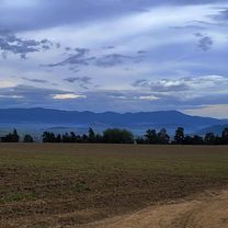
This route is for more experienced cyclists. The beginning of the trail is more demanding in terms of riding technique, moving through the forest with branches and stones. Then comes the climb under Medvediu Hlavu, and then there are long descents mixed with shorter climbs; it's a forest path, but eventually, I got to the meadows and in the end, I was left with only the asphalt road. The total distance was 30.5 km.
- -:--
- Duration
- 26.4 km
- Distance
- 532 m
- Ascent
- 532 m
- Descent
- ---
- Avg. speed
- ---
- Max. altitude

Continue with Bikemap
Use, edit, or download this cycling route
You would like to ride Smižany -Pod Medvedou Hlavou,ponad Novoveskú hutu a späť do Smižian. or customize it for your own trip? Here is what you can do with this Bikemap route:
Free features
- Save this route as favorite or in collections
- Copy & plan your own version of this route
- Sync your route with Garmin or Wahoo
Premium features
Free trial for 3 days, or one-time payment. More about Bikemap Premium.
- Navigate this route on iOS & Android
- Export a GPX / KML file of this route
- Create your custom printout (try it for free)
- Download this route for offline navigation
Discover more Premium features.
Get Bikemap PremiumFrom our community
Other popular routes starting in Spišská Nová Ves
 Suchá Belá v Slovenském ráji
- Distance
- 15.6 km
- Ascent
- 560 m
- Descent
- 559 m
- Location
- Spišská Nová Ves, Košice Region, Slovakia
 Spišská Nová Ves- Betlanovce - Hôrka -SNV.
- Distance
- 48.4 km
- Ascent
- 329 m
- Descent
- 392 m
- Location
- Spišská Nová Ves, Košice Region, Slovakia
 7 Na Spišský salaš cez Levočské vrchy
- Distance
- 68.1 km
- Ascent
- 954 m
- Descent
- 954 m
- Location
- Spišská Nová Ves, Košice Region, Slovakia
 SPišská N.Ves. Markušovce-Teplička -SNV
- Distance
- 30.1 km
- Ascent
- 352 m
- Descent
- 357 m
- Location
- Spišská Nová Ves, Košice Region, Slovakia
 Vrchol Šibeník
- Distance
- 44 km
- Ascent
- 597 m
- Descent
- 598 m
- Location
- Spišská Nová Ves, Košice Region, Slovakia
 PETLA RAJ SK
- Distance
- 77.7 km
- Ascent
- 1,106 m
- Descent
- 1,106 m
- Location
- Spišská Nová Ves, Košice Region, Slovakia
 Route to Nábrežie Hornádu 12, 052 01 Spišská Nová Ves
- Distance
- 52 km
- Ascent
- 1,509 m
- Descent
- 1,510 m
- Location
- Spišská Nová Ves, Košice Region, Slovakia
 Za banskými cestami -20160621-12:39
- Distance
- 46.1 km
- Ascent
- 1,393 m
- Descent
- 1,393 m
- Location
- Spišská Nová Ves, Košice Region, Slovakia
Open it in the app