
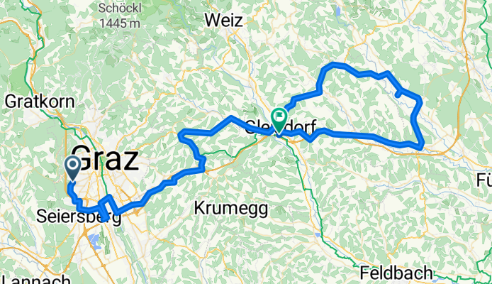
Graz - Schachblume - Gleisdorf
A cycling route starting in Wetzelsdorf, Styria, Austria.
Overview
About this route
Von Graz über den Mostwärtsrad- und Umweg, Gleisdorf und Pischelsdorf nach Großsteindorf, zum einzigen Vorkommen der Schachblume in der Steiermark.
Über Ilz zurück nach Gleisdorf und das restliche Stück mit dem Zug.
Die Schachblume blüht nur zwei Wochen lang, meist um Ostern.
Die Strecke ist nur teilweise zu empfehlen. Vor allem die B65 sollte gemieden werden - scheußlich viel Verkehr mit reger LKW-Beteiligung. Die Autobahn entlang von Nestelbach über Gleisdorf nach Ilz wär wohl die bessere Variante gewesen.
- -:--
- Duration
- 96.2 km
- Distance
- 568 m
- Ascent
- 596 m
- Descent
- ---
- Avg. speed
- ---
- Avg. speed

Route quality
Waytypes & surfaces along the route
Waytypes
Busy road
55.3 km
(57 %)
Quiet road
18.9 km
(20 %)
Surfaces
Paved
88.1 km
(92 %)
Unpaved
1.5 km
(2 %)
Asphalt
86.3 km
(90 %)
Paved (undefined)
1.3 km
(1 %)
Route highlights
Points of interest along the route
Point of interest after 68.1 km
Schachblumenwiese
Continue with Bikemap
Use, edit, or download this cycling route
You would like to ride Graz - Schachblume - Gleisdorf or customize it for your own trip? Here is what you can do with this Bikemap route:
Free features
- Save this route as favorite or in collections
- Copy & plan your own version of this route
- Split it into stages to create a multi-day tour
- Sync your route with Garmin or Wahoo
Premium features
Free trial for 3 days, or one-time payment. More about Bikemap Premium.
- Navigate this route on iOS & Android
- Export a GPX / KML file of this route
- Create your custom printout (try it for free)
- Download this route for offline navigation
Discover more Premium features.
Get Bikemap PremiumFrom our community
Other popular routes starting in Wetzelsdorf
 Mantscha
- Distance
- 37.2 km
- Ascent
- 537 m
- Descent
- 538 m
- Location
- Wetzelsdorf, Styria, Austria
 Graz Tobelbad Schwarzl Graz
- Distance
- 35.4 km
- Ascent
- 297 m
- Descent
- 297 m
- Location
- Wetzelsdorf, Styria, Austria
 Cecis 2
- Distance
- 22.4 km
- Ascent
- 598 m
- Descent
- 591 m
- Location
- Wetzelsdorf, Styria, Austria
 Kreuzweg - Luderbauer - Orthacker - Aussichtswarte - Johann & Paul - Plabutsch - Gösting - Straßgang CLONED FROM ROUTE 1162102
- Distance
- 33 km
- Ascent
- 790 m
- Descent
- 790 m
- Location
- Wetzelsdorf, Styria, Austria
 Mantscha-Umrundung
- Distance
- 28 km
- Ascent
- 455 m
- Descent
- 401 m
- Location
- Wetzelsdorf, Styria, Austria
 Kleiner Rundkurs - Grazer Westen
- Distance
- 22 km
- Ascent
- 389 m
- Descent
- 389 m
- Location
- Wetzelsdorf, Styria, Austria
 Graz nach Villach über Mur und Drau
- Distance
- 268.9 km
- Ascent
- 686 m
- Descent
- 548 m
- Location
- Wetzelsdorf, Styria, Austria
 Gemütlich rund um den Plabutsch
- Distance
- 14.4 km
- Ascent
- 240 m
- Descent
- 241 m
- Location
- Wetzelsdorf, Styria, Austria
Open it in the app