- 23.2 km
- 457 m
- 550 m
- Hürtgenwald, North Rhine-Westphalia, Germany
Großhau, Wehebach, Hürtgen
A cycling route starting in Hürtgenwald, North Rhine-Westphalia, Germany.
Overview
About this route
Loop around the Wehebachtalsperre reservoir.
Initially on paved roads, then from the end of Rennweg over gravel or unpaved paths past the Wehebachtalsperre reservoir.
The return route currently passes through extensive forestry operations. This means that the paths may sometimes be damaged by clearing and backing vehicles. (This is especially unpleasant in wet weather).
From the Brandenburg Gate, the route returns via paved roads or gravel roads back to Brandenberg.
- -:--
- Duration
- 30.6 km
- Distance
- 318 m
- Ascent
- 318 m
- Descent
- ---
- Avg. speed
- ---
- Max. altitude
created this 13 years ago
Route quality
Waytypes & surfaces along the route
Waytypes
Track
17.5 km
(57 %)
Access road
8.9 km
(29 %)
Surfaces
Paved
16.2 km
(53 %)
Unpaved
10.7 km
(35 %)
Asphalt
13.5 km
(44 %)
Gravel
7.7 km
(25 %)
Continue with Bikemap
Use, edit, or download this cycling route
You would like to ride Großhau, Wehebach, Hürtgen or customize it for your own trip? Here is what you can do with this Bikemap route:
Free features
- Save this route as favorite or in collections
- Copy & plan your own version of this route
- Sync your route with Garmin or Wahoo
Premium features
Free trial for 3 days, or one-time payment. More about Bikemap Premium.
- Navigate this route on iOS & Android
- Export a GPX / KML file of this route
- Create your custom printout (try it for free)
- Download this route for offline navigation
Discover more Premium features.
Get Bikemap PremiumFrom our community
Other popular routes starting in Hürtgenwald
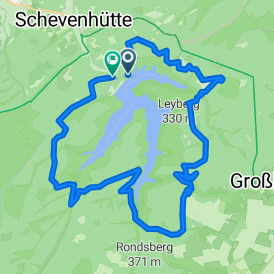
- Offroad rund um die Talsperre
- Wehebachtalsperre
- 21.4 km
- 371 m
- 371 m
- Hürtgenwald, North Rhine-Westphalia, Germany
- Hotel Kallbach Rundfahrt 30km mit Restaurant
- 29.5 km
- 564 m
- 569 m
- Hürtgenwald, North Rhine-Westphalia, Germany
- Stef@n in 3 Tagen nach Hoorn 2006
- 444 km
- 73 m
- 455 m
- Hürtgenwald, North Rhine-Westphalia, Germany
- Pfad des Gedenkens
- 9.7 km
- 324 m
- 324 m
- Hürtgenwald, North Rhine-Westphalia, Germany
- Route in Hürtgenwald
- 30.9 km
- 493 m
- 469 m
- Hürtgenwald, North Rhine-Westphalia, Germany
- Gey - Bergstein.gpx
- 8.8 km
- 163 m
- 97 m
- Hürtgenwald, North Rhine-Westphalia, Germany
- Route in Stolberg (Rheinland)
- 20 km
- 470 m
- 488 m
- Hürtgenwald, North Rhine-Westphalia, Germany
Open it in the app


