

Feierabendrunde: Ludwigshöhe
A cycling route starting in Unterhaching, Bavaria, Germany.
Overview
About this route
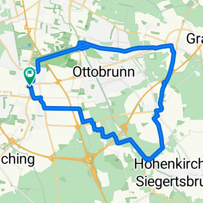
From Unterhaching S-Bahn, it goes on little-trafficked paths south towards Ludwigshöhe. Always slightly uphill. There, a wonderful view of the mountains. After that, we swing back to Unterbiberg.
- -:--
- Duration
- 36.6 km
- Distance
- 188 m
- Ascent
- 200 m
- Descent
- ---
- Avg. speed
- ---
- Max. altitude
Route quality
Waytypes & surfaces along the route
Waytypes
Quiet road
20.5 km
(56 %)
Path
9.5 km
(26 %)
Surfaces
Paved
36.6 km
(100 %)
Asphalt
36.6 km
(100 %)
Continue with Bikemap
Use, edit, or download this cycling route
You would like to ride Feierabendrunde: Ludwigshöhe or customize it for your own trip? Here is what you can do with this Bikemap route:
Free features
- Save this route as favorite or in collections
- Copy & plan your own version of this route
- Sync your route with Garmin or Wahoo
Premium features
Free trial for 3 days, or one-time payment. More about Bikemap Premium.
- Navigate this route on iOS & Android
- Export a GPX / KML file of this route
- Create your custom printout (try it for free)
- Download this route for offline navigation
Discover more Premium features.
Get Bikemap PremiumFrom our community
Other popular routes starting in Unterhaching
 rundtour Putzbrunn
- Distance
- 25.3 km
- Ascent
- 33 m
- Descent
- 31 m
- Location
- Unterhaching, Bavaria, Germany
 Feierabendrunde: Ludwigshöhe
- Distance
- 36.6 km
- Ascent
- 188 m
- Descent
- 200 m
- Location
- Unterhaching, Bavaria, Germany
 ala Sabrina München- Bad Tölz- München
- Distance
- 105.1 km
- Ascent
- 499 m
- Descent
- 499 m
- Location
- Unterhaching, Bavaria, Germany
 Münchner Forste-Gleißental-Trailtour
- Distance
- 35.5 km
- Ascent
- 87 m
- Descent
- 88 m
- Location
- Unterhaching, Bavaria, Germany
 München Ost: Rundweg Mü-Fasangarten-Bayerbrunn-Schäftlarn-Fasangarten
- Distance
- 43.1 km
- Ascent
- 222 m
- Descent
- 221 m
- Location
- Unterhaching, Bavaria, Germany
 Münchner Feierabendrunde
- Distance
- 42 km
- Ascent
- 311 m
- Descent
- 311 m
- Location
- Unterhaching, Bavaria, Germany
 Perlacher Forst - Ascholding
- Distance
- 67.7 km
- Ascent
- 485 m
- Descent
- 463 m
- Location
- Unterhaching, Bavaria, Germany
 München - Tegernsee
- Distance
- 50.1 km
- Ascent
- 378 m
- Descent
- 206 m
- Location
- Unterhaching, Bavaria, Germany
Open it in the app