
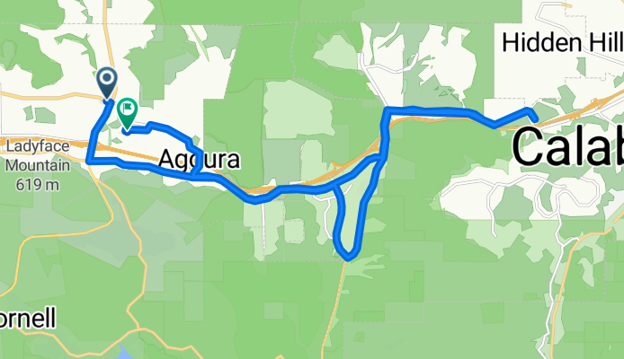
Thousand Oaks Blvd & Kanan Rd, Agoura Hills to Conejo View Drive 28860, Agoura Hills
A cycling route starting in Agoura, California, United States of America.
Overview
About this route
- 1 h 26 min
- Duration
- 25.2 km
- Distance
- 278 m
- Ascent
- 271 m
- Descent
- 17.6 km/h
- Avg. speed
- 348 m
- Avg. speed
Route quality
Waytypes & surfaces along the route
Waytypes
Road
9.1 km
(36 %)
Busy road
8.8 km
(35 %)
Surfaces
Paved
8.4 km
(33 %)
Asphalt
7.1 km
(28 %)
Concrete
1.1 km
(4 %)
Continue with Bikemap
Use, edit, or download this cycling route
You would like to ride Thousand Oaks Blvd & Kanan Rd, Agoura Hills to Conejo View Drive 28860, Agoura Hills or customize it for your own trip? Here is what you can do with this Bikemap route:
Free features
- Save this route as favorite or in collections
- Copy & plan your own version of this route
- Sync your route with Garmin or Wahoo
Premium features
Free trial for 3 days, or one-time payment. More about Bikemap Premium.
- Navigate this route on iOS & Android
- Export a GPX / KML file of this route
- Create your custom printout (try it for free)
- Download this route for offline navigation
Discover more Premium features.
Get Bikemap PremiumFrom our community
Other popular routes starting in Agoura
 Malibu Rock Store, Deer Ck, & Yerba Buena Climbs
- Distance
- 83.3 km
- Ascent
- 1,360 m
- Descent
- 1,360 m
- Location
- Agoura, California, United States of America
 Chesbro longer ride
- Distance
- 24.2 km
- Ascent
- 527 m
- Descent
- 527 m
- Location
- Agoura, California, United States of America
 Cheseboro Canyon
- Distance
- 14.9 km
- Ascent
- 243 m
- Descent
- 244 m
- Location
- Agoura, California, United States of America
 Conejo View Drive 28860, Agoura Hills to Conejo View Drive 28860, Agoura Hills
- Distance
- 23.8 km
- Ascent
- 444 m
- Descent
- 443 m
- Location
- Agoura, California, United States of America
 Latigo Piccolo
- Distance
- 54.6 km
- Ascent
- 920 m
- Descent
- 920 m
- Location
- Agoura, California, United States of America
 Westlake Loop Route 30 mile ride
- Distance
- 52.2 km
- Ascent
- 672 m
- Descent
- 671 m
- Location
- Agoura, California, United States of America
 Mullholland Highway to Cornell Rd
- Distance
- 21.4 km
- Ascent
- 274 m
- Descent
- 269 m
- Location
- Agoura, California, United States of America
 Stunt Piuma loop
- Distance
- 61.2 km
- Ascent
- 1,002 m
- Descent
- 999 m
- Location
- Agoura, California, United States of America
Open it in the app