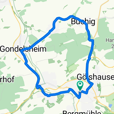
Panorama-Tour
- 52.4 km
- 426 m
- 426 m
- Bretten, Baden-Wurttemberg, Germany
A cycling route starting in Bretten, Baden-Wurttemberg, Germany.
Overview
Bretten – Büchig 19.5 km
The tour starts in Bretten at the market square. From there, head uphill on the street 'Am Gaisberg' to the main road, then turn right and take the next left into 'Apothekergasse'.
Turn right onto 'Postweg', at the end turn right and immediately left into 'Reuchlinstraße', at the roundabout turn left into 'Merianstraße' and at the fork take the bike/pedestrian path half left through the residential area.
Continue straight into the center of Gölshausen. There turn left to the roundabout, then right into 'Oberdorfstraße' and follow it out of town. At the edge of town bear slightly right, pass under the B293 and climb to the forest. Straight through the forest and at the forest edge turn right downhill towards Bauerbach.
On 'Industriestraße' to the main road and turn left into town. In the center turn right into 'Brunnenstraße', then right into 'Kapellenstraße' and at the junction with 'Rosenstraße' take the farm road slightly right, through the underpass, straight over the bridge crossing the tracks, after the bridge left and the next right downhill.
At the L554, cross straight and go through the underpass.In the industrial area go straight to the main road, turn right there and then left into 'Hirschstraße'. At its end turn left and follow 'Gochsheimer Straße' to Gochsheim.
On the main road turn left, around the left curve and just after the nursery follow the farm road about 700 m along the main road. Then gently uphill half right. At the 4-way intersection continue straight and at the ring road follow the bike path to the right under the bridge. At the T-junction turn right and at the cemetery turn left into town.
At the church turn left and then the next right into 'Bürgerstraße'. Right into 'Pfriemenstraße', then immediately right again and straight out of town.
On the hill turn right, in the hollow turn left, and past the farm to K3506. Turn right on this road, straight over the junction and downhill to Büchig.
Büchig – Bretten 32.5 km
Turn right into 'Hügellandstraße', left into 'Pfarrer Kempf Straße' and follow the road out of town straight to Neibsheim.
At the right curve of 'Steigstraße', at a sharp angle turn left, then right into 'Eichenstraße'. At its end continue straight over the main road and downhill into the valley.
At the railway embankment turn left and follow the tracks to Gondelsheim. At the station turn right and follow the main road through town.
At the roundabout turn left, through the underpass and on the farm roadparallel to the B35 to Helmsheim. There turn left into 'Kantstraße'.
Continue on 'Burggrundstraße', then left to the district road, turn right onto it and then take the next left, parallel to K3502 through the residential area out of town, then uphill on the farm road to the forest.
At the forest edge continue on the district road to Obergrombach. At the town entrance turn left into 'Burgstraße', at the city gate left, on 'Jöhlinger Straße' to the main road. Follow it left out of town.
At the field cross right onto the farm road, and at the fork half right uphill. At the second fork on the ridge turn right and downhill along the ridge to Jöhlingen.
On the main road through town. Turn left into 'Freiherr-vom-Stein-Straße', right into 'Jahnstraße', straight past the sports ground out of town. At the underpass turn right to the main road, then left into Wössingen. Turn left into 'Bruchsaler Straße'.
At the town exit turn right onto the farm road. Follow it uphill under the B293parallel to the road to Dürrenbüchig.
Over the bridge, in and through town, continue parallel to B293 towards Rinklingen. Straight through the district, under the tracks along the bike path, then right towards the station and at the traffic lights left into 'Luisenstraße'.
Turn left into 'Am Seedamm', right into 'Schlachthausgasse', then past the church uphill back to the tour starting point.
created this 13 years ago
Route quality
Track
25.7 km
(49 %)
Quiet road
15.2 km
(29 %)
Paved
45.6 km
(87 %)
Unpaved
1 km
(2 %)
Asphalt
34.6 km
(66 %)
Paved (undefined)
8.9 km
(17 %)
Continue with Bikemap
You would like to ride Panorama-Tour or customize it for your own trip? Here is what you can do with this Bikemap route:
Free trial for 3 days, or one-time payment. More about Bikemap Premium.
Discover more Premium features.
Get Bikemap PremiumFrom our community
Open it in the app