

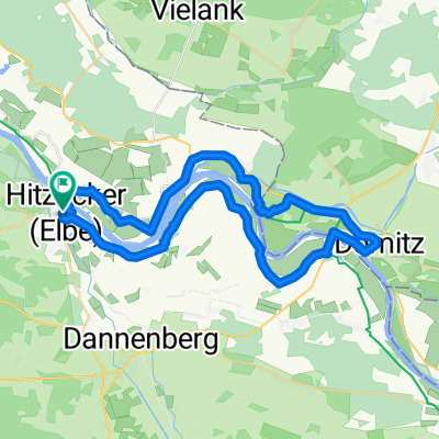
Elbhöhentour
A cycling route starting in Hitzacker, Lower Saxony, Germany.
Overview
About this route
On both sides of the Elbe, the contrasting Elbe Heights Tour runs through the landscape along the great river. On the right bank of the Elbe, between the towns of Darchau and Herrenhof, 100-year-old fruit tree avenues line the predominantly flat path through the Neuhauser Elbmarsch. In spring, a fantastic variety of blossoms defines the character of this cultural landscape. On the left bank, the densely forested Elbe heights of Drawehn and the vineyard hill in Hitzacker offer a magnificent view of the Elbe river landscape, after mastering the challenging elevation changes. The willow wetland bushes near Tiesmesland hint only faintly that once extensive floodplain forests dominated the Elbe banks.
- -:--
- Duration
- 34.1 km
- Distance
- 144 m
- Ascent
- 145 m
- Descent
- ---
- Avg. speed
- ---
- Max. altitude

Route quality
Waytypes & surfaces along the route
Waytypes
Track
14.7 km
(43 %)
Road
10.2 km
(30 %)
Surfaces
Paved
20.8 km
(61 %)
Unpaved
3.1 km
(9 %)
Concrete
11.6 km
(34 %)
Asphalt
9.2 km
(27 %)
Route highlights
Points of interest along the route

Point of interest after 0 km
Kur- und Touristinformation Hitzacker 05862-96970 hitzacker@elbtalaue-wendland.de

Point of interest after 0.1 km
Museum Das Alte Zollhaus Hitzacker www.museum-hitzacker.de

Point of interest after 0.5 km
Fähre HItzacker-Bitter Fahrzeiten und Infos unter http://www.peter-schneeberg.de/index.php?area=public&page=faehre

Point of interest after 16.4 km
Autofähre Neu Darchau - Darchau Kontakt: 0160-99162836

Point of interest after 33.8 km
Archäologisches Zentrum Hitzacker - bronzezeitliches Freilichtmuseum www.archaeo-zentrum.de
Continue with Bikemap
Use, edit, or download this cycling route
You would like to ride Elbhöhentour or customize it for your own trip? Here is what you can do with this Bikemap route:
Free features
- Save this route as favorite or in collections
- Copy & plan your own version of this route
- Sync your route with Garmin or Wahoo
Premium features
Free trial for 3 days, or one-time payment. More about Bikemap Premium.
- Navigate this route on iOS & Android
- Export a GPX / KML file of this route
- Create your custom printout (try it for free)
- Download this route for offline navigation
Discover more Premium features.
Get Bikemap PremiumFrom our community
Other popular routes starting in Hitzacker
 Hitzacker. Schöne Tour an der Elbe. Viel Natur.
- Distance
- 50.1 km
- Ascent
- 499 m
- Descent
- 496 m
- Location
- Hitzacker, Lower Saxony, Germany
 Hauptstraße nach Unterdorf
- Distance
- 112.9 km
- Ascent
- 619 m
- Descent
- 610 m
- Location
- Hitzacker, Lower Saxony, Germany
 Kiekuut_Parpar
- Distance
- 28 km
- Ascent
- 255 m
- Descent
- 261 m
- Location
- Hitzacker, Lower Saxony, Germany
 KLP2012_Plan_Freitag
- Distance
- 44.5 km
- Ascent
- 199 m
- Descent
- 199 m
- Location
- Hitzacker, Lower Saxony, Germany
 KLP 2014 Hitzacker/Breese
- Distance
- 45.3 km
- Ascent
- 49 m
- Descent
- 49 m
- Location
- Hitzacker, Lower Saxony, Germany
 Hitzacker (Elbe)-Dömitz
- Distance
- 46.6 km
- Ascent
- 143 m
- Descent
- 144 m
- Location
- Hitzacker, Lower Saxony, Germany
 Hauptstraße nach Uelzener Straße
- Distance
- 52.3 km
- Ascent
- 398 m
- Descent
- 393 m
- Location
- Hitzacker, Lower Saxony, Germany
 03-Hitzacker-Parchim-104km
- Distance
- 103.6 km
- Ascent
- 385 m
- Descent
- 356 m
- Location
- Hitzacker, Lower Saxony, Germany
Open it in the app