

2024 RadlerTreff
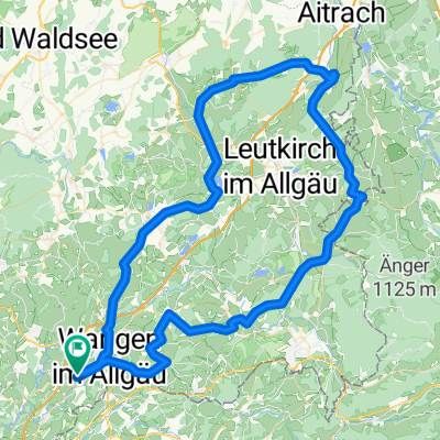
RadlerTreff 34km Amtzell - Hannober - Kongo - Geiselharz
A cycling route starting in Wangen, Baden-Wurttemberg, Germany.
Overview
About this route
- -:--
- Duration
- 34.4 km
- Distance
- 340 m
- Ascent
- 338 m
- Descent
- ---
- Avg. speed
- 682 m
- Max. altitude

Part of

2024 RadlerTreff
10 stages
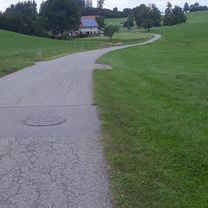
Route photos


Route quality
Waytypes & surfaces along the route
Waytypes
Quiet road
25.5 km
(74 %)
Access road
3.8 km
(11 %)
Surfaces
Paved
27.9 km
(81 %)
Unpaved
1.4 km
(4 %)
Asphalt
27.9 km
(81 %)
Unpaved (undefined)
1 km
(3 %)
Continue with Bikemap
Use, edit, or download this cycling route
You would like to ride RadlerTreff 34km Amtzell - Hannober - Kongo - Geiselharz or customize it for your own trip? Here is what you can do with this Bikemap route:
Free features
- Save this route as favorite or in collections
- Copy & plan your own version of this route
- Sync your route with Garmin or Wahoo
Premium features
Free trial for 3 days, or one-time payment. More about Bikemap Premium.
- Navigate this route on iOS & Android
- Export a GPX / KML file of this route
- Create your custom printout (try it for free)
- Download this route for offline navigation
Discover more Premium features.
Get Bikemap PremiumFrom our community
Other popular routes starting in Wangen
 Wangener Wiesenroute
- Distance
- 47.6 km
- Ascent
- 3,109 m
- Descent
- 3,680 m
- Location
- Wangen, Baden-Wurttemberg, Germany
 Mountainbiketour 2014
- Distance
- 41 km
- Ascent
- 268 m
- Descent
- 274 m
- Location
- Wangen, Baden-Wurttemberg, Germany
 von Wangen zum Schleinsee und zurück
- Distance
- 62 km
- Ascent
- 1,019 m
- Descent
- 1,021 m
- Location
- Wangen, Baden-Wurttemberg, Germany
 Missener Hausrunde
- Distance
- 18.5 km
- Ascent
- 287 m
- Descent
- 295 m
- Location
- Wangen, Baden-Wurttemberg, Germany
 Nordrunde Wangen
- Distance
- 21.4 km
- Ascent
- 311 m
- Descent
- 311 m
- Location
- Wangen, Baden-Wurttemberg, Germany
 2025 Tour 2 Barockstr. 16.06.25
- Distance
- 99.6 km
- Ascent
- 1,199 m
- Descent
- 1,198 m
- Location
- Wangen, Baden-Wurttemberg, Germany
 Wangen trail
- Distance
- 28.3 km
- Ascent
- 295 m
- Descent
- 268 m
- Location
- Wangen, Baden-Wurttemberg, Germany
 Deutsche Strassenmeisterschaft 2013 Frauen / Elite Männer
- Distance
- 42.2 km
- Ascent
- 415 m
- Descent
- 415 m
- Location
- Wangen, Baden-Wurttemberg, Germany
Open it in the app