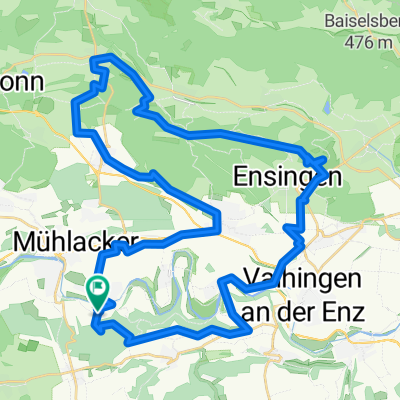
Waldenser-Tour
- 38.6 km
- 414 m
- 414 m
- Mühlacker, Baden-Wurttemberg, Germany
A cycling route starting in Mühlacker, Baden-Wurttemberg, Germany.
Overview
Schönenberg – Grossvillars 20.5 km
The tour starts at the Waldenser Museum in Schönenberg. Take the 'Erlenbacher Weg' towards Ötisheim or Mühlacker.
After the underpass, turn right, then cross the bridge over the main road on the bike/pedestrian path, through the residential area and straight past the cemetery. At the end of 'Friedhofstraße', bear half-left into 'Schönenbergstraße' and descend.
At the T-junction, turn right through the old town. Turn left onto 'Maulbronner Straße', pass the roundabout and the outdoor swimming pool, then take the farm track along the Erlenbach stream.
At the district road, turn left towards Dürrn. At the village entrance, turn right into 'Ölbronner Straße' and at the level behind the fire station, turn right onto the bike/pedestrian path towards Ölbronn.
Follow the tarmacked 'Viehweg' through the valley. At the hilltop, turn left, along K4525 into the village. Continue straight through the village centre and out of town.
Follow the farm track through the orchards to the stop. From there, take the bike/pedestrian path through the valley and at the cycle route junction, continue straight up the main road through Kleinvillars.
At the village exit, turn left, then right onto the farm track along K4520 to Knittlingen. After the underpass, turn left into 'Paul-Kieselmann-Straße', right at the next street and along 'Schiessmauerweg', 'Torstraße' and 'Marktstraße' through the village centre.
At the town hall, turn left down the main road, then right to the school, and right into 'Parkstraße' along the cemetery.
At the four-way junction after the sports ground, turn left uphill.
At the hilltop, follow the farm track right, then the next left downhill to Großvillars.
Grossvillars – Schönenberg 18.0 km
Take the main road into the village centre. At the church, turn right, past the Waldenserhäusle uphill to the viewpoint 'Derdinger Horn'. There, turn right downhill to Bernhardsweiher pond.
Turn right over the dam and at the end turn right uphill through the forest. At the saddle, straight downhill.
At the hiking car park, head to the main road and continue straight over the junction uphill, along the edge of Hohenklingen.
Shortly after the village sign, turn right onto the farm track, at the farm turn left towards the forest edge. There, turn right, gently uphill through the forest.
At the four-way junction at the forest edge (hiking car park), turn sharply left uphill and follow the wide forest track straight over the hill to Maulbronn.
At the end of 'Knittlinger Steige', turn left into 'Hilsenbeuerstraße', right into 'Gartenstraße' and to the monastery. Cross the monastery courtyard to the main road and follow it towards Schmie.
Continue straight on 'Stuttgarter Straße', then right on 'Wannenbachweg' uphill. At the top turn left, on the bike/pedestrian path to and past the sports ground.
On the road through the underpass and into Schmie.
In the village centre at the church, turn right, at the village edge turn right again and in the valley curve left.
Follow the path uphill through the forest and straight over the hill. At the residential area, straight to the main road and then left back to the tour starting point.
created this 13 years ago
Route quality
Track
22 km
(57 %)
Quiet road
9.3 km
(24 %)
Paved
28.2 km
(73 %)
Unpaved
4.2 km
(11 %)
Paved (undefined)
15.5 km
(40 %)
Asphalt
12.7 km
(33 %)
Continue with Bikemap
You would like to ride Waldenser-Tour or customize it for your own trip? Here is what you can do with this Bikemap route:
Free trial for 3 days, or one-time payment. More about Bikemap Premium.
Discover more Premium features.
Get Bikemap PremiumFrom our community
Open it in the app