Karlstraße, Illingen nach Kirchweg, Enzklösterle
- 50.2 km
- 766 m
- 639 m
- Illingen, Baden-Wurttemberg, Germany
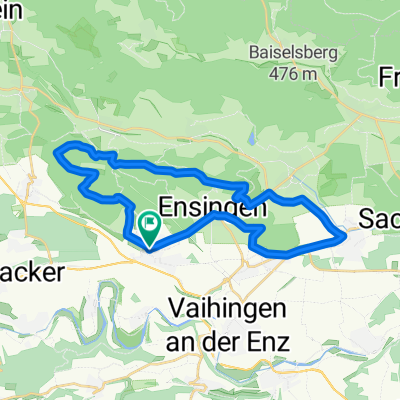
A cycling route starting in Illingen, Baden-Wurttemberg, Germany.
Overview
Illingen – Gündelbach 11.5 km
The tour starts at Illingen train station. Take the main road to the roundabout and turn right onto "Ensinger Straße" going uphill.
Take the next right onto "Zeppelinstraße" and at the end turn left onto the paved path running alongside the tracks out of Illingen.
At the industrial area, turn left to the district road and follow the bike path along it to the right towards Ensingen.
At the village entrance turn right onto "Kepler Straße", continue straight onto "Mergenthaler Straße", then left onto "Toräckerstraße". Turn left onto "Kleinglattbacher Straße", then the next right onto "Hauptstraße" and follow it through the town center.
Slight right onto "Horrheimer Straße" and continue to the town exit. There, follow the bike path along the L1106 to Horrheim.
Pass the sports ground and continue straight into town on "Eugenstraße". Turn left onto "Alte Stadtmauer Straße", right onto "Alte Schulstraße", left onto "Klosterbergstraße" and straight over the L1106 onto "St. Leonhard Straße".
Turn right onto "Plattenweg", continue straight over the bridge to the other side of the valley. There, follow the road to the left out of town.
Shortly before the T-junction, turn right onto the farm road and follow it parallel to the L1131 down the valley to Gündelbach. Follow "Reutwiesenstraße" straight into town.
Gündelbach – Illingen 17.0 km
Straight onto "Schützinger Straße" and the next left onto "Steinbruchweg". After the bridge, turn right around the bend and follow the Metter river upstream along the hillside to Schützingen.
On "Illinger Straße" go straight through the town. At the cemetery, turn left onto the farm road uphill. Along the railway embankment to and over the bridge.
After the bridge, turn right and first follow the track alignment then the main road to Zaisersweiher.
At the town entrance, half left onto "Jahnstraße" and then right onto "Wagstraße". Left, right around the bend, then straight over "Postplatz" and left onto "Poststraße".
At the T-junction, turn left, cross the stream, and on the priority road with a bend continue straight onto "Eichelbergweg". Straight uphill out of town into the forest.
At the height, go straight into the vineyard and at the first sharp-angled fork turn left into the forest.
At the fork in the forest, right, then follow the forest road straight out of the forest toward Lienzingen.
At the three-way junction by the wooded area, left downhill, at the following forks straight to the district road. On it, turn left downhill into town.
Slight left onto "Zaisersweiherer Straße" crossing the stream, then right onto "Friedrich Münch Straße" and follow it out of town.
Pass the sewage treatment plant, continue through the valley, following the Schmie river to Illingen. At the end of the farm road, straight onto the district road into town.
After about 700 m, turn right onto the bike/pedestrian path over the meadow and through the underpass.
After the underpass, turn left and return to the tour starting point.
created this 13 years ago
Route quality
Track
16.8 km
(57 %)
Quiet road
5.9 km
(20 %)
Paved
21.5 km
(73 %)
Unpaved
5 km
(17 %)
Asphalt
18 km
(61 %)
Paved (undefined)
2.9 km
(10 %)
Continue with Bikemap
You would like to ride Fachwerkdorf-Tour or customize it for your own trip? Here is what you can do with this Bikemap route:
Free trial for 3 days, or one-time payment. More about Bikemap Premium.
Discover more Premium features.
Get Bikemap PremiumFrom our community
Open it in the app